All Topics

A B C D E F G H I J K L M N O P R S T U V W
CP-29 - Enterprise GIS

Enterprise GIS is the implementation of GIS infrastructure, processes and tools at scale within the context of an organization, shaped by the prevailing information technology patterns of the day. It can be framed as an infrastructure enabling a set of capabilities, and a process for establishing and maintaining that infrastructure. Enterprise GIS facilitates the storage, sharing and dissemination of geospatial information products (data, maps, apps) within an organization and beyond. Enterprise GIS is integrated into, and shaped by the business processes, culture and context of an organization. Enterprise GIS implementations require general-purpose IT knowledge in the areas of performance tuning, information security, maintenance, interoperability, and data governance. The specific enabling technologies of Enterprise GIS will change with time, but currently the prevailing pattern is a multi-tiered services-oriented architecture supporting delivery of GIS capabilities on the web, democratizing access to and use of geospatial information products.

DM-20 - Entity-based Models
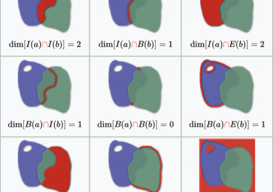
As we translate real world phenomena into data structures that we can store in a computer, we must determine the most appropriate spatial representation and how it relates to the characteristics of such a phenomenon. All spatial representations are derivatives of graph theory and should therefore be described in such terms. This then helps to understand the principles of low-level GIS operations. A constraint-driven approach allows the reader to evaluate implementations of the geo-relational principle in terms of the hierarchical level of mathematical space adopted.

GS-13 - Epistemological critiques

As GIS became a firmly established presence in geography and catalysed the emergence of GIScience, it became the target of a series of critiques regarding modes of knowledge production that were perceived as problematic. The first wave of critiques charged GIS with resuscitating logical positivism and its erroneous treatment of social phenomena as indistinguishable from natural/physical phenomena. The second wave of critiques objected to GIS on the basis that it was a representational technology. In the third wave of critiques, rather than objecting to GIS simply because it represented, scholars engaged with the ways in which GIS represents natural and social phenomena, pointing to the masculinist and heteronormative modes of knowledge production that are bound up in some, but not all, uses and applications of geographic information technologies. In response to these critiques, GIScience scholars and theorists positioned GIS as a critically realist technology by virtue of its commitment to the contingency of representation and its non-universal claims to knowledge production in geography. Contemporary engagements of GIS epistemologies emphasize the epistemological flexibility of geospatial technologies.

FC-02 - Epistemology

Epistemology is the lens through which we view reality. Different epistemologies interpret the earth and patterns on its surface differently. In effect, epistemology is a belief system about the nature of reality that, in turn, structures our interpretation of the world. Common epistemologies in GIScience include (but are not limited by) positivism and realism. However, many researchers are in effect pragmatists in that they choose the filter that best supports their work and a priori hypotheses. Different epistemologies – or ways of knowing and studying geography – result in different ontologies or classification systems. By understanding the role of epistemology, we can better understand different ways of representing the same phenomena.

AM-106 - Error-based Uncertainty

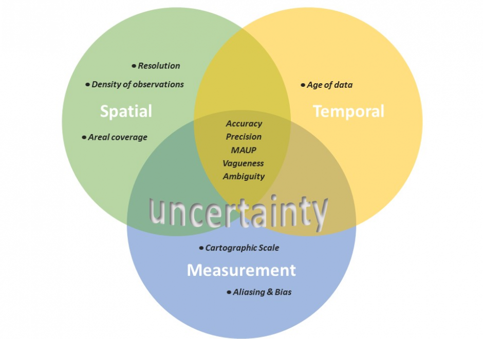
The largest contributing factor to spatial data uncertainty is error. Error is defined as the departure of a measure from its true value. Uncertainty results from: (1) a lack of knowledge of the extent and of the expression of errors and  (2) their propagation through analyses. Understanding error and its sources is key to addressing error-based uncertainty in geospatial practice. This entry presents a sample of issues related to error and error based uncertainty in spatial data. These consist of (1) types of error in spatial data, (2) the special case of scale and its relationship to error and (3) approaches to quantifying error in spatial data.

CP-26 - eScience, the Evolution of Science

Science—and research more broadly—face many challenges as its practitioners struggle to accommodate new challenges around reproducibility and openness.  The current practice of science limits access to knowledge, information and infrastructure, which in turn leads to inefficiencies, frustrations and a lack of rigor.  Many useful research outcomes are never used because they are too difficult to find, or to access, or to understand.

New computational methods and infrastructure provide opportunities to reconceptualize how science is conducted, how it is shared, how it is evaluated and how it is reused.  And new data sources changed what can be known, and how well, and how frequently.  This article describes some of the major themes of eScience/eResearch aimed at improving the process of doing science.

GS-12 - Ethics for Certified Geospatial Professionals

This entry discusses ethics for certified geospatial professional, focusing on the Codes of Ethics for the American Society for Photogrammetry and Remote Sensing (ASPRS) and the GIS Certification Institute (GISCI). The entry begins by defining and discussing ethics, while providing some history of the evolution of ethics in the GIS community. It then compares and contrasts the ethical guidelines of GISCI and ASPRS, including sanctions that may be imposed upon individuals who have violated their codes of ethics. The entry concludes with a discussion of how certified professionals may address situations in which their codes of ethics may conflict with their employers’ proprietary interests.

GS-15 - Feminist Critiques of GIS

Feminist interactions with GIS started in the 1990s in the form of strong critiques against GIS inspired by feminist and postpositivist theories. Those critiques mainly highlighted a supposed epistemological dissonance between GIS and feminist scholarship. GIS was accused of being shaped by positivist and masculinist epistemologies, especially due to its emphasis on vision as the principal way of knowing. In addition, feminist critiques claimed that GIS was largely incompatible with positionality and reflexivity, two core concepts of feminist theory. Feminist critiques of GIS also discussed power issues embedded in GIS practices, including the predominance of men in the early days of the GIS industry and the development of GIS practices for the military and surveillance purposes.

At the beginning of the 21st century, feminist geographers reexamined those critiques and argued against an inherent epistemological incompatibility between GIS methods and feminist scholarship. They advocated for a reappropriation of GIS by feminist scholars in the form of critical feminist GIS practices. The critical GIS perspective promotes an unorthodox, reconstructed, and emancipatory set of GIS practices by critiquing dominant approaches of knowledge production, implementing GIS in critically informed progressive social research, and developing postpositivist techniques of GIS. Inspired by those debates, feminist scholars did reclaim GIS and effectively developed feminist GIS practices.

CV-31 - Flow Maps

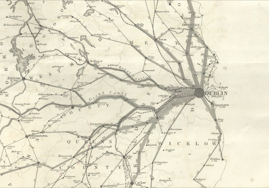
Flow mapping is a cartographic method of representing movement of phenomena. Maps of this type often depict the vector movement of entities (imports and exports, people, information) between geographic areas, but the general method also encompasses a range of graphics illustrating networks (e.g., transit and communications grids) and dynamic systems (e.g., wind and water currents). Most flow maps typically use line symbols of varying widths, lengths, shapes, colors, or speeds (in the case of animated flow maps) to show the quality, direction, and magnitude of movements. Aesthetic considerations for flow maps are numerous and their production is often done manually without significant automation. Flow maps frequently use distorted underlying geography to accommodate the placement of flow paths, which are often dramatically smoothed/abstracted into visually pleasing curves or simply straight lines. In the extreme, such maps lack a geographic coordinate space and are more diagrammatic, as in Sankey diagrams, alluvial diagrams, slope graphs, and circle migration plots. Whatever their form, good flow maps should effectively visualize the relative magnitude and direction of movement or potential movement between a one or more origins and destinations.

PD-33 - GDAL/OGR and Geospatial Data IO Libraries

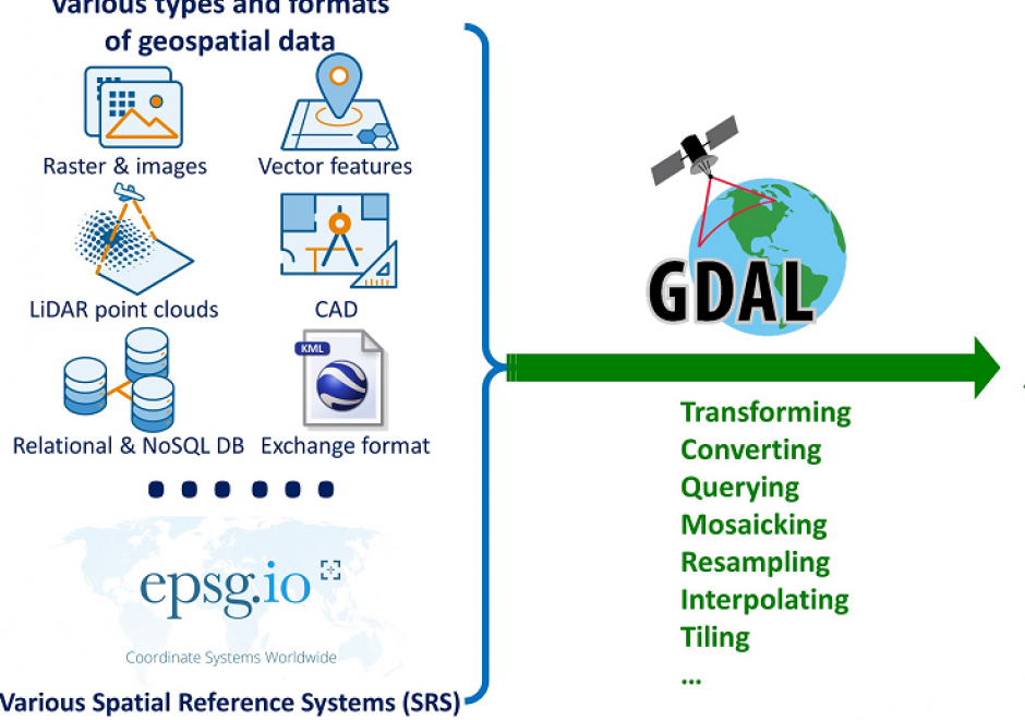
Manipulating (e.g., reading, writing, and processing) geospatial data, the first step in geospatial analysis tasks, is a complicated step, especially given the diverse types and formats of geospatial data combined with diverse spatial reference systems. Geospatial data Input/Output (IO) libraries help facilitate this step by handling some technical details of the IO process. GDAL/OGR is the most widely-used, broadly-supported, and constantly-updated free library among existing geospatial data IO libraries. GDAL/OGR provides a single raster abstract data model and a single vector abstract data model for processing and analyzing raster and vector geospatial data, respectively, and it supports most, if not all, commonly-used geospatial data formats. GDAL/OGR can also perform both cartographic projections on large scales and coordinate transformation for most of the spatial reference systems used in practice. This entry provides an overview of GDAL/OGR, including why we need such a geospatial data IO library and how it can be applied to various formats of geospatial data to support geospatial analysis tasks. Alternative geospatial data IO libraries are also introduced briefly. Future directions of development for GDAL/OGR and other geospatial data IO libraries in the age of big data and cloud computing are discussed as an epilogue to this entry.

Pages