education

KE-32 - Competence in GIS&T Knowledge Work

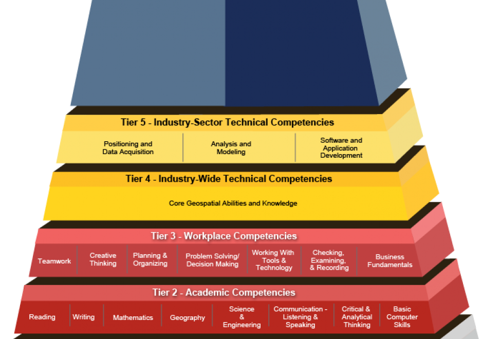
“Competence” is a word that rolls off the tongues of instructional designers, education administrators, and HR people. Others find it hard to swallow. For some GIS&T educators, competence connotes an emphasis on vocational instruction that’s unworthy of the academy. This entry challenges skeptical educators to rethink competence not just as readiness for an occupation, but first and foremost as the readiness to live life to the fullest, and to contribute to a sustainable future. The entry considers the OECD’s “Key Competencies for a Successful Life and Well-Functioning Society,” as well as the specialized GIS&T competencies specified in the U.S. Department of Labor’s Geospatial Technology Competency Model. It presents findings of a survey in which 226 self-selected members of Esri’s Young Professionals Network observe that competencies related to the GTCM’s Software and App Development Segment were under-developed in their university studies. Looking ahead, in the context of an uncertain future in which, some say, many workers are at risk of “technological unemployment,” the entry considers which GIS&T competencies are likely to be of lasting value.

KE-25 - GIS&T Education and Training

GIS education and training have their roots both in formal educational settings and in professional development.  Methods and approaches for teaching and learning about and with geospatial technologies have evolved in tight connection with the advances in the internet and personal computers.  The adoption and integration of GIS and related geospatial technologies into dozens of academic disciplines has led to a high demand for instruction that is targeted and timely, a combination that is challenging to meet consistently with diverse audiences and in diverse settings. Academic degrees, concentrations, minors, certificates, and numerous other programs abound within formal and informal education.

CV-28 - Lesson Design in Cartography Education

This entry describes six general variables of lesson design in cartography education and offers some practical advice for the development of materials for teaching cartography. First, a lesson’s scope concerns the set of ideas included in a lesson and helps identify different types of lessons based on the kinds of knowledge that they contain. Second, learning objectives concern the things that students should be able to do following a lesson and relate to different cognitive processes of learning. Third, a lesson’s scheme deals with the organizational framework for delivering content. Fourth, a lesson’s guidance concerns the amount and quality of supportive information provided. Fifth, a lesson’s sequence may involve one or more strategies for ordering content. Sixth, a lesson’s activity concerns what students do during a lesson and is often associated with different learning outcomes. These six variables help differentiate traditions for teaching cartography, elucidate some of the recurring challenges in cartography education, and offer strategies for designing lessons to foster meaningful learning outcomes.

KE-32 - Competence in GIS&T Knowledge Work

“Competence” is a word that rolls off the tongues of instructional designers, education administrators, and HR people. Others find it hard to swallow. For some GIS&T educators, competence connotes an emphasis on vocational instruction that’s unworthy of the academy. This entry challenges skeptical educators to rethink competence not just as readiness for an occupation, but first and foremost as the readiness to live life to the fullest, and to contribute to a sustainable future. The entry considers the OECD’s “Key Competencies for a Successful Life and Well-Functioning Society,” as well as the specialized GIS&T competencies specified in the U.S. Department of Labor’s Geospatial Technology Competency Model. It presents findings of a survey in which 226 self-selected members of Esri’s Young Professionals Network observe that competencies related to the GTCM’s Software and App Development Segment were under-developed in their university studies. Looking ahead, in the context of an uncertain future in which, some say, many workers are at risk of “technological unemployment,” the entry considers which GIS&T competencies are likely to be of lasting value.

KE-25 - GIS&T Education and Training

GIS education and training have their roots both in formal educational settings and in professional development.  Methods and approaches for teaching and learning about and with geospatial technologies have evolved in tight connection with the advances in the internet and personal computers.  The adoption and integration of GIS and related geospatial technologies into dozens of academic disciplines has led to a high demand for instruction that is targeted and timely, a combination that is challenging to meet consistently with diverse audiences and in diverse settings. Academic degrees, concentrations, minors, certificates, and numerous other programs abound within formal and informal education.
CV-28 - Lesson Design in Cartography Education

This entry describes six general variables of lesson design in cartography education and offers some practical advice for the development of materials for teaching cartography. First, a lesson’s scope concerns the set of ideas included in a lesson and helps identify different types of lessons based on the kinds of knowledge that they contain. Second, learning objectives concern the things that students should be able to do following a lesson and relate to different cognitive processes of learning. Third, a lesson’s scheme deals with the organizational framework for delivering content. Fourth, a lesson’s guidance concerns the amount and quality of supportive information provided. Fifth, a lesson’s sequence may involve one or more strategies for ordering content. Sixth, a lesson’s activity concerns what students do during a lesson and is often associated with different learning outcomes. These six variables help differentiate traditions for teaching cartography, elucidate some of the recurring challenges in cartography education, and offer strategies for designing lessons to foster meaningful learning outcomes.

KE-32 - Competence in GIS&T Knowledge Work

“Competence” is a word that rolls off the tongues of instructional designers, education administrators, and HR people. Others find it hard to swallow. For some GIS&T educators, competence connotes an emphasis on vocational instruction that’s unworthy of the academy. This entry challenges skeptical educators to rethink competence not just as readiness for an occupation, but first and foremost as the readiness to live life to the fullest, and to contribute to a sustainable future. The entry considers the OECD’s “Key Competencies for a Successful Life and Well-Functioning Society,” as well as the specialized GIS&T competencies specified in the U.S. Department of Labor’s Geospatial Technology Competency Model. It presents findings of a survey in which 226 self-selected members of Esri’s Young Professionals Network observe that competencies related to the GTCM’s Software and App Development Segment were under-developed in their university studies. Looking ahead, in the context of an uncertain future in which, some say, many workers are at risk of “technological unemployment,” the entry considers which GIS&T competencies are likely to be of lasting value.

Pages