standards

KE-34 - Multi-Organizational GIS Coordination

For many years, collaboration has been a key cornerstone in the success of efforts achieved by the geospatial community.  When paired with governance, collaborative efforts often lead to sustainability and have the effect of broadening the benefits that can be achieved.  The following text shares how the geospatial community uses collaboration and governance as tools to achieve benefits across the community.  Case studies are provided to illustrate the process and the outcomes achieved. 

DM-79 - U.S. National Spatial Data Infrastructure
Spatial data infrastructures may be thought of as socio-technical frameworks for coordinating the development, management, sharing and use of geospatial data across multiple organizational jurisdictions and varying geographic extents. The United States was an early adopter of the SDI concept and the U.S. National Spatial Data Infrastructure (NSDI) is an example of a country-wide SDI implementation facilitated by coordination at the federal-government level. At the time of its establishment in the early 1990s, a unique characteristic of the NSDI was a mandate for federal agencies to establish partnerships with state- and local-level government. This entry summarizes the origins of the NSDI’s establishment, its original core components and how they’ve evolved over the last 25 years, the role of the Federal Geographic Data Committee (FGDC), and the anticipated impact of passage of the Geospatial Data Act of 2018. For broader technical information about SDIs, readers are referred to GIST BoK Entry DM-60: Spatial Data Infrastructures (Hu and Li 2017). For additional details on the history of the NSDI, readers are referred to Rhind (1999). For the latest information on recent and emerging NSDI initiatives, please visit the FGDC web site (www.fgdc.gov).  

DM-62 - Database Administration

Organizations with a responsibility for maintaining large-scale, multi-user spatial databases often turn to server-based relational database management systems to achieve their goals.  The administration of such databases has many dimensions.  Industry standards in the areas of data storage and services should be researched and applied to ensure a sound, comprehensive database design as well as to promote interoperability with external entities.  Data validation tools should be implemented to improve the accuracy and efficiency of data maintenance activities.  Metadata should be maintained according to industry standards to protect the organization’s investment in data and to increase the likelihood of the data being located by clearinghouse and portal search tools.  Database security strategies can prevent unauthorized access to data and lessen the chances of data loss due to accidental data corruption.  Database performance should be monitored and strategies implemented to ensure that data can be retrieved from the system with acceptable response times.  Finally, trends in the field such as the increasing need to manage large volumes of data call for spatial database managers to be knowledgeable of non-relational data models as well, such as NoSQL data models.

KE-34 - Multi-Organizational GIS Coordination

For many years, collaboration has been a key cornerstone in the success of efforts achieved by the geospatial community.  When paired with governance, collaborative efforts often lead to sustainability and have the effect of broadening the benefits that can be achieved.  The following text shares how the geospatial community uses collaboration and governance as tools to achieve benefits across the community.  Case studies are provided to illustrate the process and the outcomes achieved. 

DM-79 - U.S. National Spatial Data Infrastructure

Spatial data infrastructures may be thought of as socio-technical frameworks for coordinating the development, management, sharing and use of geospatial data across multiple organizational jurisdictions and varying geographic extents. The United States was an early adopter of the SDI concept and the U.S. National Spatial Data Infrastructure (NSDI) is an example of a country-wide SDI implementation facilitated by coordination at the federal-government level. At the time of its establishment in the early 1990s, a unique characteristic of the NSDI was a mandate for federal agencies to establish partnerships with state- and local-level government. This entry summarizes the origins of the NSDI’s establishment, its original core components and how they’ve evolved over the last 25 years, the role of the Federal Geographic Data Committee (FGDC), and the anticipated impact of passage of the Geospatial Data Act of 2018. For broader technical information about SDIs, readers are referred to GIST BoK Entry DM-60: Spatial Data Infrastructures (Hu and Li 2017). For additional details on the history of the NSDI, readers are referred to Rhind (1999). For the latest information on recent and emerging NSDI initiatives, please visit the FGDC web site (www.fgdc.gov).  

DM-62 - Database Administration

Organizations with a responsibility for maintaining large-scale, multi-user spatial databases often turn to server-based relational database management systems to achieve their goals.  The administration of such databases has many dimensions.  Industry standards in the areas of data storage and services should be researched and applied to ensure a sound, comprehensive database design as well as to promote interoperability with external entities.  Data validation tools should be implemented to improve the accuracy and efficiency of data maintenance activities.  Metadata should be maintained according to industry standards to protect the organization’s investment in data and to increase the likelihood of the data being located by clearinghouse and portal search tools.  Database security strategies can prevent unauthorized access to data and lessen the chances of data loss due to accidental data corruption.  Database performance should be monitored and strategies implemented to ensure that data can be retrieved from the system with acceptable response times.  Finally, trends in the field such as the increasing need to manage large volumes of data call for spatial database managers to be knowledgeable of non-relational data models as well, such as NoSQL data models.

KE-34 - Multi-Organizational GIS Coordination

For many years, collaboration has been a key cornerstone in the success of efforts achieved by the geospatial community.  When paired with governance, collaborative efforts often lead to sustainability and have the effect of broadening the benefits that can be achieved.  The following text shares how the geospatial community uses collaboration and governance as tools to achieve benefits across the community.  Case studies are provided to illustrate the process and the outcomes achieved. 

DM-79 - U.S. National Spatial Data Infrastructure

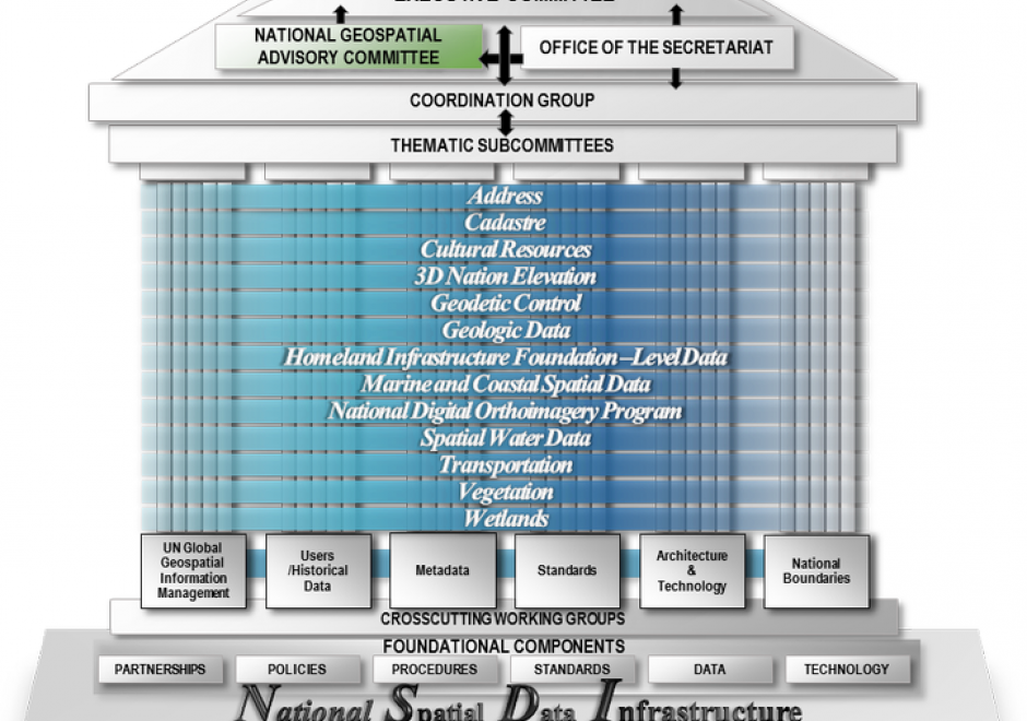
Spatial data infrastructures may be thought of as socio-technical frameworks for coordinating the development, management, sharing and use of geospatial data across multiple organizational jurisdictions and varying geographic extents. The United States was an early adopter of the SDI concept and the U.S. National Spatial Data Infrastructure (NSDI) is an example of a country-wide SDI implementation facilitated by coordination at the federal-government level. At the time of its establishment in the early 1990s, a unique characteristic of the NSDI was a mandate for federal agencies to establish partnerships with state- and local-level government. This entry summarizes the origins of the NSDI’s establishment, its original core components and how they’ve evolved over the last 25 years, the role of the Federal Geographic Data Committee (FGDC), and the anticipated impact of passage of the Geospatial Data Act of 2018. For broader technical information about SDIs, readers are referred to GIST BoK Entry DM-60: Spatial Data Infrastructures (Hu and Li 2017). For additional details on the history of the NSDI, readers are referred to Rhind (1999). For the latest information on recent and emerging NSDI initiatives, please visit the FGDC web site (www.fgdc.gov).  
DM-62 - Database Administration

Organizations with a responsibility for maintaining large-scale, multi-user spatial databases often turn to server-based relational database management systems to achieve their goals.  The administration of such databases has many dimensions.  Industry standards in the areas of data storage and services should be researched and applied to ensure a sound, comprehensive database design as well as to promote interoperability with external entities.  Data validation tools should be implemented to improve the accuracy and efficiency of data maintenance activities.  Metadata should be maintained according to industry standards to protect the organization’s investment in data and to increase the likelihood of the data being located by clearinghouse and portal search tools.  Database security strategies can prevent unauthorized access to data and lessen the chances of data loss due to accidental data corruption.  Database performance should be monitored and strategies implemented to ensure that data can be retrieved from the system with acceptable response times.  Finally, trends in the field such as the increasing need to manage large volumes of data call for spatial database managers to be knowledgeable of non-relational data models as well, such as NoSQL data models.

Pages