2018 QUARTER 02

A B C D E F G H I K L M N O P R S T U V W
AM-22 - Global measures of spatial association
  • Describe the effect of the assumption of stationarity on global measures of spatial association
  • Justify, compute, and test the significance of the join count statistic for a pattern of objects
  • Compute the K function
  • Explain how a statistic that is based on combining all the spatial data and returning a single summary value or two can be useful in understanding broad spatial trends
  • Compute measures of overall dispersion and clustering of point datasets using nearest neighbor distance statistics
  • Compute Moran’s I and Geary’s c for patterns of attribute data measured on interval/ratio scales
  • Explain how the K function provides a scale-dependent measure of dispersion
DC-03 - Global Positioning System
  • Explain how GPS receivers calculate coordinate data
  • Discuss the relationship of GPS to the Global Satellite Navigation System
  • Explain “selective availability,” why it was discontinued in 2000, and what alternatives are available to the U.S. Department of Defense
  • Explain the relationship of the U.S. Global Positioning System with comparable systems sponsored by Russia and the European Union and the Global Navigation Satellite System
  • Discuss the role of GPS in location-based services (LBS)
  • Specify the features of a GPS receiver that is able to achieve geometric accuracies on the order of centimeters without post-processing
  • Explain the relevance of the concept of trilateration to both GPS positioning and control surveying
  • Perform differential correction of GPS data using reference data from a CORS station
  • List, define, and rank the sources of error associated with GPS positioning
  • Distinguish between horizontal and vertical accuracies when using coarse acquisition codes/standard positioning service (C-codes) and precision acquisition codes/precise positioning service (P-codes)
CP-06 - Graphics Processing Units (GPUs)

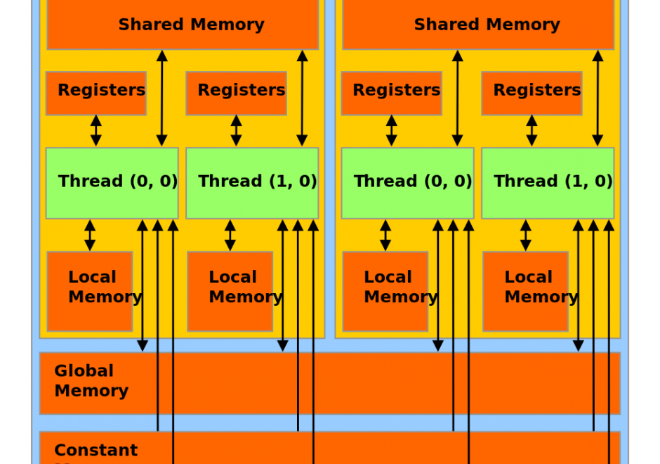
Graphics Processing Units (GPUs) represent a state-of-the-art acceleration technology for general-purpose computation. GPUs are based on many-core architecture that can deliver computing performance much higher than desktop computers based on Central Processing Units (CPUs). A typical GPU device may have hundreds or thousands of processing cores that work together for massively parallel computing. Basic hardware architecture and software standards that support the use of GPUs for general-purpose computation are illustrated by focusing on Nvidia GPUs and its software framework: CUDA. Many-core GPUs can be leveraged for the acceleration of spatial problem-solving.  

AM-73 - Greedy heuristics
  • Demonstrate how to implement a greedy heuristic process
  • Identify problems for which the greedy heuristic also produces the optimal solution (e.g., Kruskal’s algorithm for minimum spanning tree, the fractional Knapsack problem)
DM-08 - Grid compression methods
  • Illustrate the existing methods for compressing gridded data (e.g., run length encoding, Lempel-Ziv, wavelets)
  • Explain the advantage of wavelet compression
  • Evaluate the relative merits of grid compression methods for storage
  • Differentiate between lossy and lossless compression methods
DM-06 - Grid representations
  • Explain how grid representations embody the field-based view
  • Differentiate among a lattice, a tessellation, and a grid
  • Explain how terrain elevation can be represented by a regular tessellation and by an irregular tessellation
  • Identify the national framework datasets based on a grid model
DC-19 - Ground verification and accuracy assessment
  • Evaluate the thematic accuracy of a given soils map
  • Explain how U.S. Geological Survey scientists and contractors assess the accuracy of the National Land Cover Dataset

Pages