2018 QUARTER 02

A B C D E F G H I K L M N O P R S T U V W
AM-14 - Spatial process models
  • Discuss the relationship between spatial processes and spatial patterns
  • Differentiate between deterministic and stochastic spatial process models
  • Describe a simple process model that would generate a given set of spatial patterns
FC-13 - Spatial queries
  • Demonstrate the syntactic structure of spatial and temporal operators in SQL
  • State questions that can be solved by selecting features based on location or spatial relationships
  • Construct a query statement to search for a specific spatial or temporal relationship
  • Construct a spatial query to extract all point objects that fall within a polygon
  • Compare and contrast attribute query and spatial query
DC-07 - Spatial sample types
  • Design point, transect, and area sampling strategies for given applications
  • Differentiate between situations in which one would use stratified random sampling and systematic sampling
  • Differentiate among random, systematic, stratified random, and stratified systematic unaligned sampling strategies
AM-26 - Spatial sampling for statistical analysis
  • List and describe several spatial sampling schemes and evaluate each one for specific applications
  • Differentiate between model-based and design-based sampling schemes
  • Design a sampling scheme that will help detect when space-time clusters of events occur
  • Create spatial samples under a variety of requirements, such as coverage, randomness, and transects
  • Describe sampling schemes for accurately estimating the mean of a spatial data set
DM-18 - Spatio-temporal GIS
  • Describe extensions to relational DBMS to represent temporal change in attributes
  • Evaluate the advantages and disadvantages of existing space-time models based on storage efficiency, query performance, ease of data entry, and ability to implement in existing software
  • Create a GIS database that models temporal information
  • Utilize two different space-time models to characterize a given scenario, such as a daily commute
  • Describe the architecture of data models (both field and object based) to represent spatio-temporal phenomena
  • Differentiate the two types of temporal information to be modeled in databases: database (or transaction) time and valid (or world) time
  • Identify whether it is important to represent temporal change in a particular GIS application
  • Describe SQL extensions for querying temporal change
DC-23 - State and regional coordinating bodies
  • Describe how state GIS councils can be used in enterprise GIS&T implementation processes
  • Explain the functions, mission, history, constituencies, and activities of your state GIS Council and related formal and informal bodies
  • Discuss how informal and formal regional bodies (e.g., Metro GIS) can help support GIS&T in an organization
  • Discuss the mission, history, constituencies, and activities of National States Geographic Information Council (NSGIC)
  • Determine if your state has a Geospatial Information Office (GIO) and discuss the mission, history, constituencies, and activities of a GIO
CV-05 - Statistical Mapping (Enumeration, Normalization, Classification, Dasymetric)
  • Discuss advantages and disadvantages of various data classification methods for choropleth mapping, including equal interval, quantiles, mean-standard deviation, natural breaks, and “optimal” methods
  • Demonstrate how different classification schemes produce very different maps from a single set of interval- or ratio-level data
  • Write algorithms to perform equal interval, quantiles, mean-standard deviation, natural breaks, and “optimal” classification for choropleth mapping
DC-13 - Stereoscopy and orthoimagery
  • Explain the relevance of the concept “parallax” in stereoscopic aerial imagery
  • Evaluate the advantages and disadvantages of photogrammetric methods and LiDAR for production of terrain elevation data
  • Specify the technical components of an aerotriangulation system
  • Outline the sequence of tasks involved in generating an orthoimage from a vertical aerial photograph
FC-12 - Structured Query Language (SQL) and attribute queries
  • Define basic terms of query processing (e.g., SQL, primary and foreign keys, table join)
  • Create an SQL query to retrieve elements from a GIS
  • Explain the basic logic of SQL syntax
  • Demonstrate the basic syntactic structure of SQL
CV-08 - Symbolization and the Visual Variables

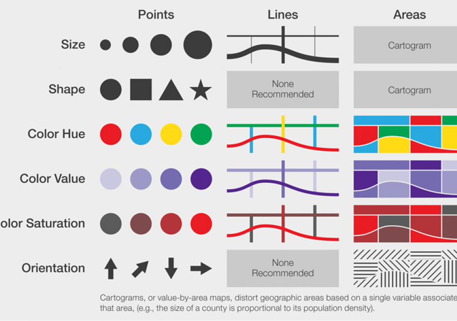
Maps communicate information about the world by using symbols to represent specific ideas or concepts. The relationship between a map symbol and the information that symbol represents must be clear and easily interpreted. The symbol design process requires first an understanding of the underlying nature of the data to be mapped (e.g., its spatial dimensions and level of measurement), then the selection of symbols that suggest those data attributes. Cartographers developed the visual variable system, a graphic vocabulary, to express these relationships on maps. Map readers respond to the visual variable system in predictable ways, enabling mapmakers to design map symbols for most types of information with a high degree of reliability.

Pages