2018 QUARTER 03

A B C D E F G H I K L M N O P R S T U V W
FC-03 - Philosophical perspectives
  • Define common philosophical theories that have influenced geography and science, such as logical positivism, Marxism, phenomenology, feminism, and critical theory
  • Identify the philosophical views and assumptions underlying the work of colleagues
  • Describe a brief history of major philosophical movements relating to the nature of space, time, geographic phenomena and human interaction with it
  • Compare and contrast the kinds of questions various philosophies ask, the methodologies they use, the answers they offer, and their applicability to different phenomena
  • Evaluate the influences of one’s own philosophical views and assumptions on GIS&T practices
  • Defend or refute the statement, “All data are theory-laden”
DM-36 - Physical Data Models
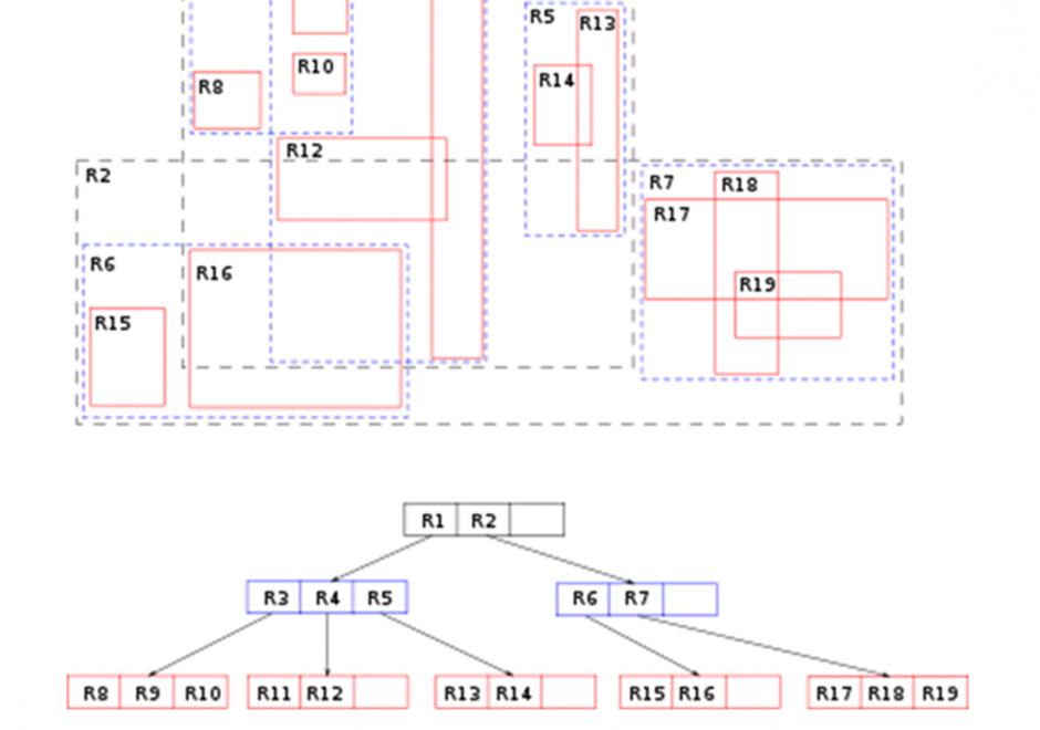
Constructs within a particular implementation of database management software guide the development of a physical data model, which is a product of a physical database design process. A physical data model documents how data are to be stored and accessed on storage media of computer hardware.  A physical data model is dependent on specific data types and indexing mechanisms used within database management system software.  Data types such as integers, reals, character strings, plus many others can lead to different storage structures. Indexing mechanisms such as region-trees and hash functions and others lead to differences in access performance.  Physical data modeling choices about data types and indexing mechanisms related to storage structures refine details of a physical database design. Data types associated with field, record and file storage structures together with the access mechanisms to those structures foster (constrain) performance of a database design. Since all software runs using an operating system, field, record, and file storage structures must be translated into operating system constructs to be implemented.  As such, all storage structures are contingent on the operating system and particular hardware that host data management software. 

FC-06 - Place and landscape
  • Explain how the concept of place encompasses more than just location
  • Evaluate the differences in how various parties think or feel differently about a place being modeled
  • Describe the elements of a sense of place or landscape that are difficult or impossible to adequately represent in GIS
  • Differentiate between space and place
  • Differentiate among elements of the meaning of a place that can or cannot be easily represented using geospatial technologies
  • Select a place or landscape with personal meaning and discuss its importance
  • Define the notions of cultural landscape and physical landscape
DM-48 - Plane coordinate systems
  • Explain why plane coordinates are sometimes preferable to geographic coordinates
  • Identify the map projection(s) upon which UTM coordinate systems are based, and explain the relationship between the projection(s) and the coordinate system grid
  • Discuss the magnitude and cause of error associated with UTM coordinates
  • Differentiate the characteristics and uses of the UTM coordinate system from the Military Grid Reference System (MGRS) and the World Geographic Reference System (GEOREF)
  • Explain what State Plane Coordinates system (SPC) eastings and northings represent
  • Associate SPC coordinates and zone specifications with corresponding positions on a U.S. map or globe
  • Identify the map projection(s) upon which SPC coordinate systems are based, and explain the relationship between the projection(s) and the coordinate system grids
  • Discuss the magnitude and cause of error associated with SPC coordinates
  • Recommend the most appropriate plane coordinate system for applications at different spatial extents and justify the recommendation
  • Critique the U.S. Geological Survey’s choice of UTM as the standard coordinate system for the U.S. National Map
  • Describe the characteristics of the “national grids” of countries other than the U.S.
  • Explain what Universal Transverse Mercator (UTM) eastings and northings represent
  • Associate UTM coordinates and zone specifications with corresponding position on a world map or globe
AM-07 - Point pattern analysis
  • List the conditions that make point pattern analysis a suitable process
  • Identify the various ways point patterns may be described
  • Identify various types of K-function analysis
  • Describe how Independent Random Process/Chi-Squared Result (IRP/CSR) may be used to make statistical statements about point patterns
  • Outline measures of pattern based on first and second order properties such as the mean center and standard distance, quadrat counts, nearest neighbor distance, and the more modern G, F, and K functions
  • Outline the basis of classic critiques of spatial statistical analysis in the context of point pattern analysis
  • Explain how distance-based methods of point pattern measurement can be derived from a distance matrix
  • Explain how proximity polygons (e.g., Thiessen polygons) may be used to describe point patterns
  • Explain how the K function provides a scale-dependent measure of dispersion
  • Compute measures of overall dispersion and clustering of point datasets using nearest neighbor distance statistics
GS-19 - Political influences
  • Recognize the constraints that political forces place on geospatial applications in public and private sectors
  • Evaluate the influences of political ideologies (e.g., Marxism, Capitalism, conservative/liberal) on the understanding of geographic information
  • Evaluate the influences of political actions, especially the allocation of territory, on human perceptions of space and place
FC-28 - Primary and secondary data sources
  • Explain the distinction between primary and secondary data sources in terms of census data, cartographic data, and remotely sensed data
  • Describe a scenario in which data from a secondary source may pose obstacles to effective and efficient use
AM-27 - Principles of semi-variogram construction
  • Identify and define the parameters of a semi-variogram (range, sill, nugget)
  • Demonstrate how semi-variograms react to spatial nonstationarity
  • Construct a semi-variogram and illustrate with a semi-variogram cloud
  • Describe the relationships between semi-variograms and correlograms, and Moran’s indices of spatial association
FC-30 - Private sector origins
  • Identify some of the key commercial activities that provided an impetus for the development of GIS&T
  • Differentiate the dominant industries using geospatial technologies during the 1980s, 1990s, and 2000s
  • Describe the contributions of McHarg and other practitioners in developing geographic analysis methods later incorporated into GIS
  • Evaluate the correspondence between advances in hardware and operating system technology and changes in GIS software
  • Describe the influence of evolving computer hardware and of private sector hardware firms such as IBM on the emerging GIS software industry
  • Discuss the emergence of the GIS software industry in terms of technology evolution and markets served by firms such as ESRI, Intergraph, and ERDAS
KE-02 - Problem definition
  • Recognize the challenges of implementing and using geospatial technologies
  • Create a charter or hypothesis that defines and justifies the mission of a GIS to solve existing problems
  • Define an enterprise GIS in terms of institutional missions and goals
  • Identify geographic tasks for which particular geospatial technologies are not adequate or sufficient
  • Identify what is typically needed to garner support among managers for designing and/or creating a GIS

Pages