2018 QUARTER 04

A B C D E F G H I K L M N O P R S T U V W
FC-19 - Networks Defined

A network is a widely used term with different definitions and methodologies depending on the applications. In GIS, a network refers to an arrangement of elements (i.e., nodes, links) and information on their connections and interactions. There are two types of networks: physical and logical. While a physical network has tangible objects (e.g., road segments), a logical network represents logical connections among nodes and links. A network can be represented with a mathematical notion called graph theory. Different network components are utilized to describe characteristics of a network including loops, walks, paths, circuits, and parallel edges. Network data are commonly organized in a vector format with network topology, specifically connectivity among nodes and links, whereas raster data can be also utilized for a least-cost problem over continuous space. Network data is utilized in a wide range of network analyses, including the classic shortest path problem.

DM-67 - NoSQL Databases
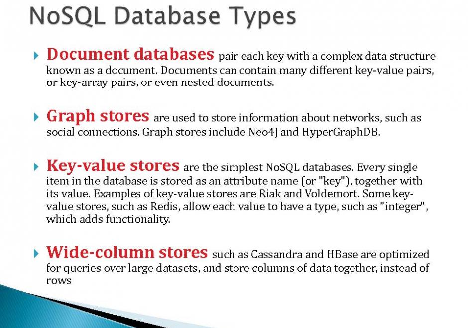
NoSQL databases are open-source, schema-less, horizontally scalable and high-performance databases. These characteristics make them very different from relational databases, the traditional choice for spatial data. The four types of data stores in NoSQL databases (key-value store, document store, column store, and graph store) contribute to significant flexibility for a range of applications. NoSQL databases are well suited to handle typical challenges of big data, including volume, variety, and velocity. For these reasons, they are increasingly adopted by private industries and used in research. They have gained tremendous popularity in the last decade due to their ability to manage unstructured data (e.g. social media data).

DM-04 - Object-oriented DBMS
  • Describe the basic elements of the object-oriented paradigm, such as inheritance, encapsulation, methods, and composition
  • Evaluate the degree to which the object-oriented paradigm does or does not approximate cognitive structures
  • Explain how the principle of inheritance can be implemented using an object-oriented programming approach
  • Defend or refute the notion that the Extensible Markup Language (XML) is a form of object-oriented database
  • Explain how the properties of object orientation allows for combining and generalizing objects
  • Evaluate the advantages and disadvantages of object-oriented databases compared to relational databases, focusing on representational power, data entry, storage efficiency, and query performance
  • Implement a GIS database design in an off-the-shelf, object-oriented database
  • Differentiate between object-oriented programming and object-oriented databases
FC-35 - Openness

The philosophy of Openness and its use in diverse areas is attracting increasing attention from users, developers, businesses, governments, educators, and researchers around the world. The technological, socio-cultural, economic, legal, institutional, and philosophical issues related to its principles, applications, benefits, and barriers for its use are growing areas of research. The word “Open” is commonly used to denote adherence to the principles of Openness. Several fields are incorporating the use of Openness in their activities, some of them are of particular relevance to GIS&T (Geographic Information Science and Technology) such as: Open Data, Free and Open Source Software; and Open Standards for geospatial data, information, and technologies. This entry presents a definition of Openness, its importance in the area of GISc&T is introduced through a list of its benefits in the fields of Open Data, Open Source Software, and Open Standards. Then some of the barriers, myths, or inhibitors to Openness are presented using the case of Free and Open Source Software (FOSS) and FOSS for Geospatial Applications (FOSS4G).

FC-34 - Organizational models for coordinating GISs and/or program participants and stakeholders
  • Compare and contrast centralized, federated, and distributed models for managing information infrastructures
  • Describe the roles and relationships of GIS&T support staff
  • Exemplify how to make GIS&T relevant to top management
  • Describe different organizational models for coordinating GIS&T participants and stakeholders
  • Describe the stages of two different models of implementing a GIS within an organization
KE-33 - Organizational Models for GIS Management

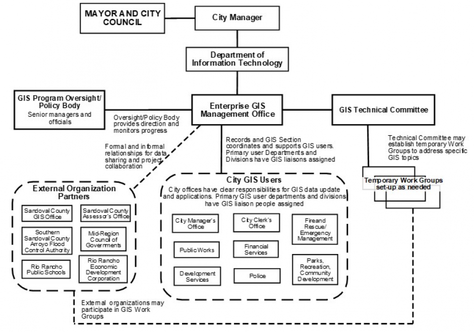
Organizational structures and management practices for GIS programs are numerous and complex. This topic begins with an explanation of organizational and management concepts and context that are particularly relevant to GIS program and project management, including strategic planning and stakeholders. Specific types of organizations that typically use GIS technology are described and organizational structure types are explained. For GIS Program management, organizational placement, organizational components, and management control and policies are covered in depth. Multi-organizational GIS Programs are also discussed. Additional topics include management roles and technology trends that affect organizational structure. It concludes with a general description of GIS Project management. 

AM-43 - Other classic network problems
  • Describe several classic problems to which network analysis is applied (e.g., the traveling salesman problem, the Chinese postman problem)
  • Explain why heuristic solutions are generally used to address the combinatorially complex nature of these problems and the difficulty of solving them optimally
AM-04 - Overlay
  • Explain why the process “dissolve and merge” often follows vector overlay operations
  • Outline the possible sources of error in overlay operations
  • Compare and contrast the concept of overlay as it is implemented in raster and vector domains
  • Demonstrate how the geometric operations of intersection and overlay can be implemented in GIS
  • Demonstrate why the georegistration of datasets is critical to the success of any map overlay operation
  • Formalize the operation called map overlay using Boolean logic
  • Explain what is meant by the term “planar enforcement”
  • Exemplify applications in which overlay is useful, such as site suitability analysis
AM-38 - Pattern recognition
  • Differentiate among machine learning, data mining, and pattern recognition
  • Explain the principles of pattern recognition
  • Apply a simple spatial mean filter to an image as a means of recognizing patterns
  • Construct an edge-recognition filter
  • Design a simple spatial mean filter
  • Explain the outcome of an artificial intelligence analysis (e.g., edge recognition), including a discussion of what the human did not see that the computer identified and vice versa
FC-04 - Perception and cognition of geographic phenomena
  • Describe the differences between real phenomena, conceptual models, and GIS data representations thereof
  • Explain the role of metaphors and image schema in our understanding of geographic phenomena and geographic tasks
  • Compare and contrast the symbolic and connectionist theories of human cognition and memory and their ability to model various cases
  • Compare and contrast theories of spatial knowledge acquisition (e.g., Marr on vision, Piaget on childhood, Golledge on wayfinding)
  • Explore the contribution of linguistics to the study of spatial cognition and the role of natural language in the conceptualization of geographic phenomena

Pages