2019 QUARTER 03

A B C D E F G H I K L M N O P R S T U V W
KE-04 - Application user assessment
  • Identify current and potential users of geospatial technology in an enterprise
  • Identify new geographic tasks or information that align with institutional missions and goals
  • Educate potential users on the value of geospatial technology
  • Classify potential users as casual or professional, early adopters or reluctant users
  • Recognize geographic tasks and geographic information that already exist in an enterprise
  • Evaluate the potential for using geospatial technology to improve the efficiency and/or effectiveness of existing activities
  • Differentiate the concepts of efficiency and effectiveness in application requirements
DA-07 - Applications in federal government
  • List and describe the types of data maintained by federal governments
  • Explain how geospatial information might be used in a taking of private property through a government’s claim of its right of eminent domain
  • Describe how geospatial data are used and maintained for land use planning, property value assessment, maintenance of public works, and other applications
  • Explain the concept of a “spatial decision support system”
DA-05 - Applications in local government
  • List and describe the types of data maintained by local governments
  • Explain how geospatial information might be used in a taking of private property through a government’s claim of its right of eminent domain
  • Describe how geospatial data are used and maintained for land use planning, property value assessment, maintenance of public works, and other applications
  • Explain the concept of a “spatial decision support system”
DA-06 - Applications in state government
  • List and describe the types of data maintained by state governments
  • Explain how geospatial information might be used in a taking of private property through a government’s claim of its right of eminent domain
  • Describe how geospatial data are used and maintained for land use planning, property value assessment, maintenance of public works, and other applications
  • Explain the concept of a “spatial decision support system”
AM-62 - Approaches to point, line, and area generalization
  • Describe the basic forms of generalization used in applications in addition to cartography (e.g., selection, simplification)
  • Explain why areal generalization is more difficult than line simplification
  • Explain the logic of the Douglas-Poiker line simplification algorithm
  • Explain the pitfalls of using data generalized for small scale display in a large scale application
  • Design an experiment that allows one to evaluate the effect of traditional approaches of cartographic generalization on the quality of digital data sets created from analog originals
  • Evaluate various line simplification algorithms by their usefulness in different applications
  • Discuss the possible effects on topological integrity of generalizing data sets
DM-44 - Approximating the Earth's shape with geoids
  • Explain why gravity varies over the Earth’s surface
  • Explain how geoids are modeled
  • Explain the role that the U.S. National Geodetic Survey plays in maintaining and developing geoid models
  • Explain the concept of an equipotential gravity surface (i.e., a geoid)
FC-16 - Area and Region
  • List reasons why the area of a polygon calculated in a GIS might not be the same as the real world object it describes
  • Demonstrate how the area of a region calculated from a raster data set will vary by resolution and orientation
  • Outline an algorithm to find the area of a polygon using the coordinates of its vertices
  • Explain how variations in the calculation of area may have real world implications, such as calculating density
  • Delineate regions using properties, spatial relationships, and geospatial technologies
  • Exemplify regions found at different scales
  • Explain the relationship between regions and categories
  • Identify the kinds of phenomena commonly found at the boundaries of regions
  • Explain why general-purpose regions rarely exist
  • Differentiate among different types of regions, including functional, cultural, physical, administrative, and others
  • Compare and contrast the opportunities and pitfalls of using regions to aggregate geographic information (e.g., census data)
  • Use established analysis methods that are based on the concept of region (e.g., landscape ecology)
  • Explain the nature of the Modifiable Areal Unit Problem (MAUP)
DM-81 - Array Databases

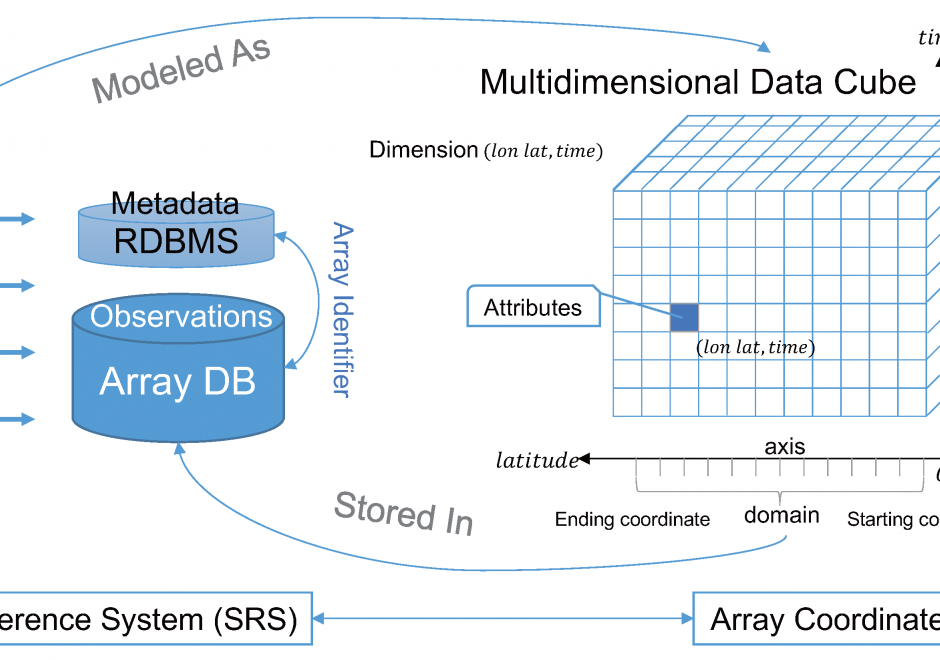
Array Databases are a class of No-SQL databases that store, manage, and analyze data whose natural structures are arrays. With the growth of large volumes of spatial data (i.e., satellite imagery) there is a pressing need to have new ways to store and manipulate array data. Currently, there are several databases and platforms that have extended their initial architectures to support for multidimensional arrays. However, extending a platform to support a multidimensional array comes at a performance cost, when compared to Array Databases who specialize in the storage, retrieval, and processing of n-dimensional data.

CP-04 - Artificial intelligence
  • Describe computational intelligence methods that may apply to GIS&T
  • Exemplify the potential for machine learning to expand performance of specialized geospatial analysis functions
  • Identify artificial intelligence tools that may be useful for GIS&T
  • Describe a hypothesis space that includes searches for optimality of solutions within that space

Pages