2019 QUARTER 04

A B C D E F G H I K L M N O P R S T U V W
AM-12 - Cartographic modeling
  • Describe the difference between prescriptive and descriptive cartographic models
  • Develop a flowchart of a cartographic model for a site suitability problem
  • Discuss the origins of cartographic modeling with reference to the work of Ian McHarg
CV-27 - Cartography and Art
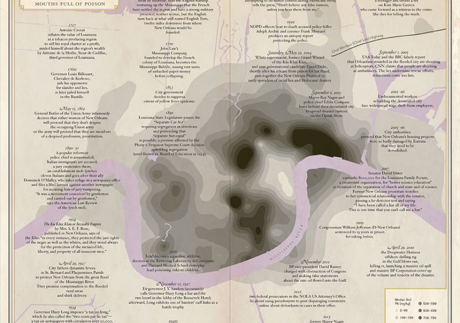
The intersections between art and cartography go far beyond the notions of design and illustration, since mapmaking invariably has multiple cultural, social, and political dimensions. Considering this broader perspective, this entry provides a review of these different contemporary intersections, by exploring three main types of relationships: 1) cartography influenced by artistic practices; 2) map art or maps embedded in artistic practices; and 3) cartography at the interface between art and places. These will be discussed in detail following a brief overview of the main historical markers from which these types of relationships between art and cartography have emerged.

CV-26 - Cartography and Power

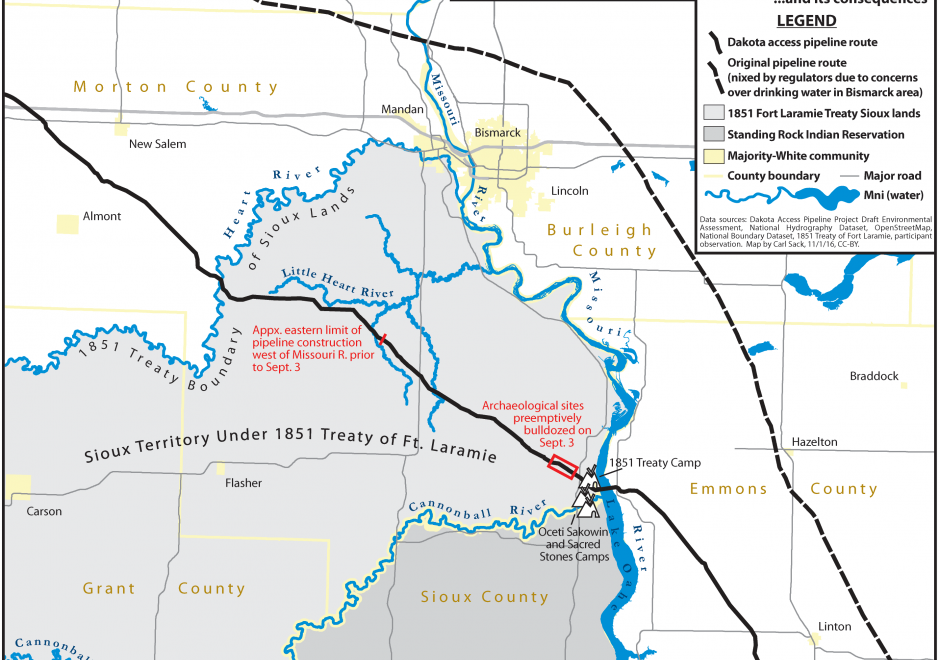
Over twenty five years ago, Brian Harley (1989, p. 2) implored cartographers to “search for the social forces that have structured cartography and to locate the presence of power – and its effects – in all map knowledge.” In the intervening years, while Harley has become a bit of a touchstone for citational practices acknowledging critical cartography (Edney, 2015), both theoretical understandings of power as well as the tools and technologies that go into cartographic production have changed drastically. This entry charts some of the many ways that power may be understood to manifest within and through maps and mapmaking practices. To do so, after briefly situating work on cartography and power historically, it presents six critiques of cartography and power in the form of dialectics. First, building from Harley’s earlier work, it defines a deconstructivist approach to mapping and places it in contrast to hermeneutic phenomenological approaches. Second, it places state-sanctioned practices of mapping against participatory and counter-mapping ones. Third, epistemological understanding of maps and their affects are explored through the dialectic of the map as a static object versus more processual, ontogenetic understandings of maps. Finally, the chapter concludes by suggesting the incomplete, heuristic nature of both the approaches and ideas explored here as well as the practices of critical cartography itself. Additional resources for cartographers and GIScientists seeking to further explore critical approaches to maps are provided.

CV-01 - Cartography and Science
  • Discuss the perspectives of Brian Harley and others on the political motivation for the development of certain kinds of maps
  • Discuss the Swiss influence on map design and production, highlighting Imhof’s contributions
  • Outline the development of some of the major map projections (e.g., Mercator, Gnomonic, Robinson)
  • Explain how Bertin has influenced trends in cartographic symbolization
  • Explain how technological changes have affected cartographic design and production
  • Explain the impact of advances in visualization methods on the evolution of cartography
  • Compare and contrast cartographic developments in various countries and world regions such as Switzerland, France, China, the Middle East, and Greece
  • Discuss the influence of some cartographers of the 16th and 17th centuries (Mercator, Ortelius, Jansson, Homann and others)
  • Describe how compilation, production, and distribution methods used in map-making have evolved
  • Describe how symbolization methods used in map-making have evolved
  • Describe the contributions by Robinson, Jenks, Raisz, and others to U.S. academic cartography
  • Discuss the relationship between the history of exploration and the development of a more accurate map of the world
CV-02 - Cartography and Technology
  • Discuss the impact that mapping on the Web via applications such as Google Earth have had on the practice of cartography
  • Explain how emerging technologies in related fields (e.g., the stereoplotter, aerial and satellite imagery, GPS and LiDAR, the World Wide Web, immersive and virtual environments) have advanced cartography and visualization methods
  • Explain how MacEachren’s Cartography-cubed (C3) concept can be used to understand the evolving role of cartography and visualization
  • Explain how software innovations such as Synagraphic Mapping System (SYMAP), Surfer, and automated contouring methods have affected the design of maps
  • Evaluate the advantages and limitations of various technological approaches to mapping
  • Select new technologies in related fields that have the most potential for use in cartography and visualization
AM-69 - Cellular Automata

Cellular automata (CA) are simple models that can simulate complex processes in both space and time. A CA consists of six defining components: a framework, cells, a neighborhood, rules, initial conditions, and an update sequence. CA models are simple, nominally deterministic yet capable of showing phase changes and emergence, map easily onto the data structures used in geographic information systems, and are easy to implement and understand. This has contributed to their popularity for applications such as measuring land use changes and monitoring disease spread, among many others.

GS-24 - Citizen Science with GIS&T

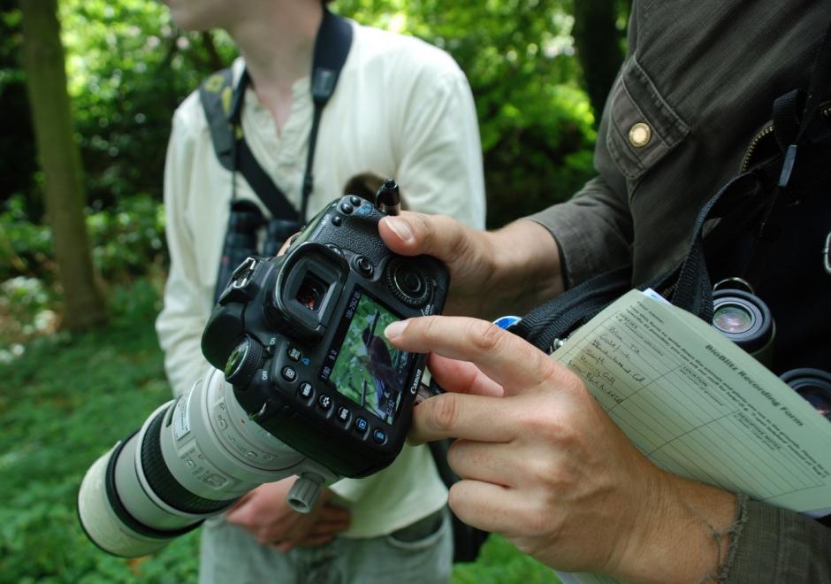
Figure 1. Participant in a BioBlitz records bird observation (Source: Jo Somerfield)


Citizen Science is defined as the participation of non-professional volunteers in scientific projects (Dickson et al, 2010) and has experienced rapid growth over the past decade. The projects that are emerging in this area range from contributory projects, co-created projects, collegiate projects, which are initiated and run by a group of people with shared interest, without any involvement of professional scientists.  

In many citizen science projects, GIS&T is enabling the collection, analysis, and visualisation of spatial data to affect decision-making. Some examples may include:

  • Recording the location of invasive species or participating in a BioBlitz to record local biodiversity (Figure 1).
  • Measuring air quality or noise over a large area and over time to monitor local conditions and address them
  • Using tools to educate on and increase access to local resources,  improving community resilience

Such projects have the opportunity to empower or disempower members of the public, depending upon access to and understanding of technology. Citizen Science projects using GIS&T may help communities influence decision makers and support the gathering of large-scale scientific evidence on a range of issues. This may also renew people’s interests in the sciences and foster continued and lifelong learning. 


DM-14 - Classic vector data models
  • Illustrate the GBF/DIME data model
  • Describe a Freeman-Huffman chain code
  • Describe the relationship of Freeman-Huffman chain codes to the raster model
  • Discuss the impact of early prototype data models (e.g., POLYVRT and GBF/DIME) on contemporary vector formats
  • Describe the relationship between the GBF/DIME and TIGER structures, the rationale for their design, and their intended primary uses, paying particular attention to the role of graph theory in establishing the difference between GBF/DIME and TIGER files
  • Discuss the advantages and disadvantages of POLYVRT
  • Explain what makes POLYVRT a hierarchical vector data model
AM-09 - Cluster analysis
  • Identify several cluster detection techniques and discuss their limitations
  • Demonstrate the extension of spatial clustering to deal with clustering in space-time using the Know and Mantel tests
  • Perform a cluster detection analysis to detect “hot spots” in a point pattern
  • Discuss the characteristics of the various cluster detection techniques

Pages