2021 QUARTER 02

A B C D E F G H I J K L M N O P R S T U V W
GS-02 - Contract law
  • Differentiate “contracts for service” from “contracts of service”
  • Discuss potential legal problems associated with licensing geospatial information
  • Identify the liability implications associated with contracts
DM-88 - Coordinate transformations
  • Cite appropriate applications of several coordinate transformation techniques (e.g., affine, similarity, Molodenski, Helmert)
  • Describe the impact of map projection transformation on raster and vector data
  • Differentiate between polynomial coordinate transformations (including linear) and rubbersheeting
GS-18 - Cultural influences
  • Collaborate effectively with colleagues of differing social backgrounds in developing balanced GIS applications
  • Describe the ways in which the elements of culture (e.g., language, religion, education, traditions) may influence the understanding and use of geographic information
  • Recognize the impact of one’s social background on one’s own geographic worldview and perceptions and how it influences one’s use of GIS
CP-13 - Cyberinfrastructure

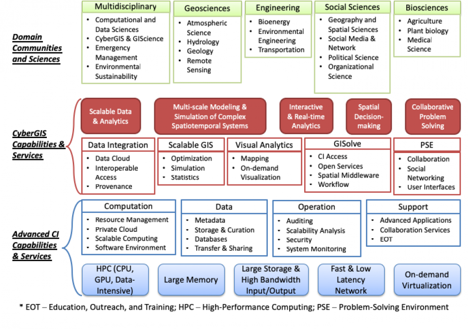
Cyberinfrastructure (sometimes referred to as e-infrastructure and e-science) integrates cutting-edge digital environments to support collaborative research and education for computation- and/or data-intensive problem solving and decision making (Wang 2010).

AM-57 - Data conversion
  • Identify the conceptual and practical difficulties associated with data model and format conversion
  • Convert a data set from the native format of one GIS product to another
  • Discuss the role of metadata in facilitating conversation of data models and data structures between systems
  • Describe a workflow for converting and implementing a data model in a GIS involving an Entity-Relationship (E-R) diagram and the Universal Modeling Language (UML)
DM-02 - Data retrieval strategies
  • Analyze the relative performance of data retrieval strategies
  • Implement algorithms that retrieve geospatial data from a range of data structures
  • Describe the particular advantages of Morton addressing relative to geographic data representation
  • Discuss the advantages and disadvantages of different data structures (e.g., arrays, linked lists, binary trees, hash tables, indexes) for retrieving geospatial data
  • Compare and contrast direct and indirect access search and retrieval methods
KE-18 - Data sharing among public and private agencies, organizations, and individuals
  • Describe formal and informal arrangements that promote geospatial data sharing (e.g., FGDC, ESDI, memoranda of agreements, informal access arrangements, targeted funding support)
  • Describe a situation in which politics interferes with data sharing and exchange
DM-59 - Data warehouses
  • Differentiate between a data warehouse and a database
  • Describe the functions that gazetteers support
  • Differentiate the retrieval mechanisms of data warehouses and databases
  • Discuss the appropriate use of a data warehouse versus a database
DM-62 - Database administration
  • Describe how using standards can affect implementation of a GIS
  • Explain how validation and verification processes can be used to maintain database integrity
  • Summarize how data access processes can be a factor in development of an enterprise GIS implementation
  • Describe effective methods to get stakeholders to create, adopt, or develop and maintain metadata for shared datasets
CV-29 - Design and Aesthetics

Design and aesthetics are fundamental to cartographic practice. Developing students’ skills in design and aesthetics is a critical part of cartography education, yet design is also one of the most difficult part of the cartographic process. The cartographic design process of planning, creating, critiquing, and revising maps provides a method for making maps with intentional design decisions, utilizing an understanding of aesthetics to promote clarity and cohesion to attract the user and facilitate an emotional response. In this entry, cartographic design and the cartographic design process are reviewed, and the concepts of aesthetics, style, and taste are explained in the context of cartographic design.

Pages