Data Capture

The capture of massive quantities of spatial data, able to be distributed and shared in real time, provide for an ever-increasing range of environmental and societal applications. Data capture includes the principles, methods, technologies, applications, and institutional/programmatic aspects of spatial data acquisition. Sources of data include global navigation satellite systems, satellite and aerial sensing, field surveys, land records, socioeconomic data (e.g., census), volunteered geographic information, wireless sensor networks, and unmanned aerial systems.

Topics in this Knowledge Area are listed thematically below. Existing topics are in regular font and linked directly to their original entries (published in 2006; these contain only Learning Objectives). Entries that have been updated and expanded are in bold. Forthcoming, future topics are italicized


History & Trends Processing Remotely-Sensed Data
Changes in Data Capture Methods Over Time, Part 1: Technological Developments Image Interpretation: Aerial Photography & Satellites
Changes in Data Capture Over Time, Part 2: Implications and Case Studies Feature Extraction in Satellite Imagery
Georeferencing and Georectification Structure from Motion Photogrammetry
Digital Data Sources & Capture Methods Ground Verification and Accuracy Assessment
Historical (Paper) Maps Spectral Properties of Terrestrial Surfaces
Global Navigation Satellite Systems  
Mobile Applications GIS and Surveying
Aerial Photography: History & Georeferencing Professional Land Surveying
Ground or Street-Level Imagery Land records
Social Media Platforms Ocean Surveying
Texts  
Volunteered Geographic Information (VGI) Field Data Collection
Remote Sensing Platforms & Sensors Sampling: Size Selection, Sample Types, Intervals
Remote Sensing Platforms overview Field Data Capture Technologies
Nature of multispectral image data U.S. Census Data
Unmanned Aerial Systems (UAS) Data Coordinating Organizations
Landsat Multi-Organizational GIS Coordination
Light Detection and Ranging (LiDAR) Federal Agencies & National Organizations and Programs
Indoor LiDAR Scanning International Organizations & Programs
Thermal Imagery  
Radar, Sonar, and Echolocation  
Hyperspectral Imagery  
Airborne LiDAR Bathymetry  


DC-21 - Spatial data sharing among organizations
  • Describe the rationale for and against sharing data among organizations
  • Describe the barriers to information sharing
  • Describe methods used by organizations to facilitate data sharing
DC-13 - Stereoscopy and orthoimagery
  • Explain the relevance of the concept “parallax” in stereoscopic aerial imagery
  • Evaluate the advantages and disadvantages of photogrammetric methods and LiDAR for production of terrain elevation data
  • Specify the technical components of an aerotriangulation system
  • Outline the sequence of tasks involved in generating an orthoimage from a vertical aerial photograph
DC-11 - Street-level Imagery

Street-level imagery consists of collections of photographs taken from the perspective of moving pedestrians or vehicles. These collections are often stitched together digitally and georeferenced to create interactive and immersive landscapes that are virtually navigable by users. Such landscapes, sometimes called 360-degree panoramas, or bubbles, are uploaded onto web platforms, and linked with geographical databases, which allows users to search and explore the imagery in various ways. IT companies such as Google have created street-level imagery platforms that rely primarily on paid drivers, although they have begun to rely on contributor submissions to complement and expand their coverage. Recently services such as Mapillary and OpenStreetCam have advanced a model that relies primarily on volunteer contributors, leveraging community interest from projects such as OpenStreetMap. While street-level imagery has become a widespread tool with multiple commercial and non-commercial applications, it is also entangled various legal and public opinion controversies, due to its capabilities for private data collection and surveillance. 

DC-39 - Time-of-Arrival (TOA) Localization for Indoor GIS

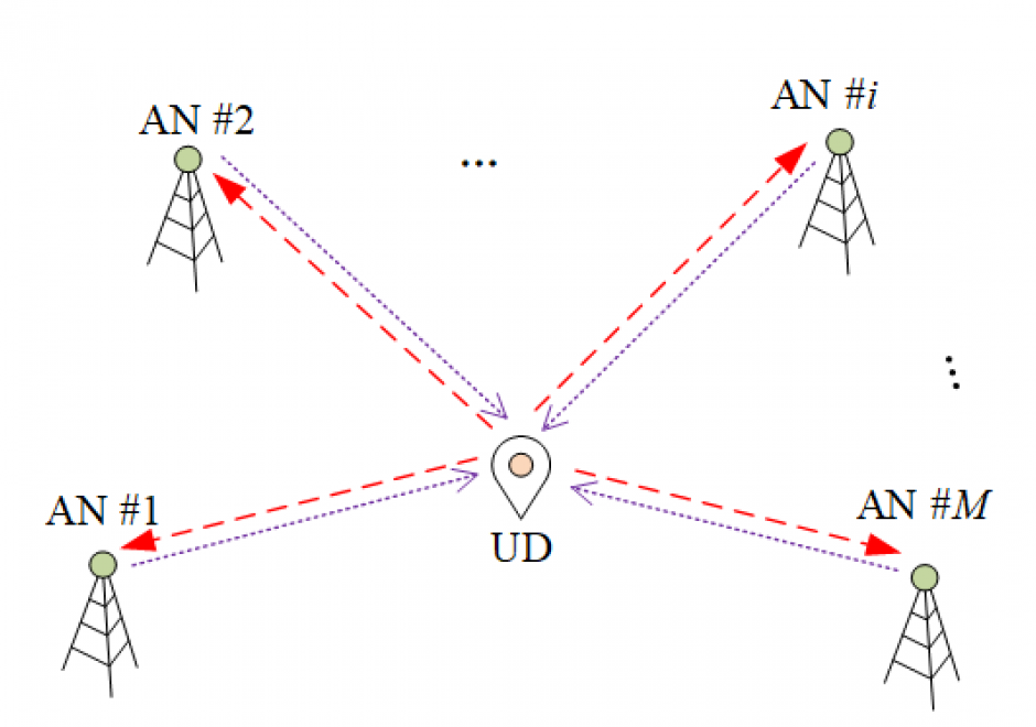
Indoor geographic information system (GIS) opens up a new frontier for identifying, analyzing and solving complex problems. In many indoor GIS-driven applications such as indoor wayfinding and logistics planning and management, determination of location information deserves special attention because global positioning system (GPS) may be inaccessible. Alternative methods and systems have emerged to overcome this hurdle. The time-of-arrival (TOA) measurement is one of the most adopted metrics in numerous modern systems such as radar, acoustic/ultra-sound-based tracking, ultra-wide band (UWB) indoor localization, wireless sensor networks (WSN) and Internet of things (IoT) localization. This topic presents the TOA technique and methods to solve the localization and synchronization problem. We also introduce variants of the TOA system schemes, which are adopted by real-world applications. As a use case of the TOA technique realized in practice, a UWB localization system is introduced. Examples are given to demonstrate that indoor localization and GIS are tightly interconnected.

DC-28 - United States Census Data

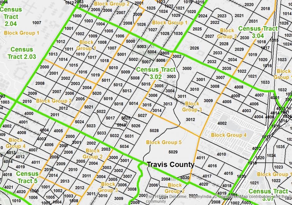
The Census Bureau collects extensive numeric data on the residents of the United States as well ast the national economy.  This is accomplished both through a decennial census as well as numerous other more frequent surveys. The decennial census is a fundamental basis of American democracy, mandated by the U.S. Constitution and essential for the equal representation in a democratic government. Numeric census data are maintained in vast collections of tables and organized at many different levels of geographies. From the Census website, the geographic and tabular data can be downloaded and then joined for display and analysis within a GIS. Because of the nature of individual data aggregated over areas and other matters, care must be taken to avoid statistical errors when undertaking spatial analyses.

DC-24 - Unmanned Aerial Systems (UAS)

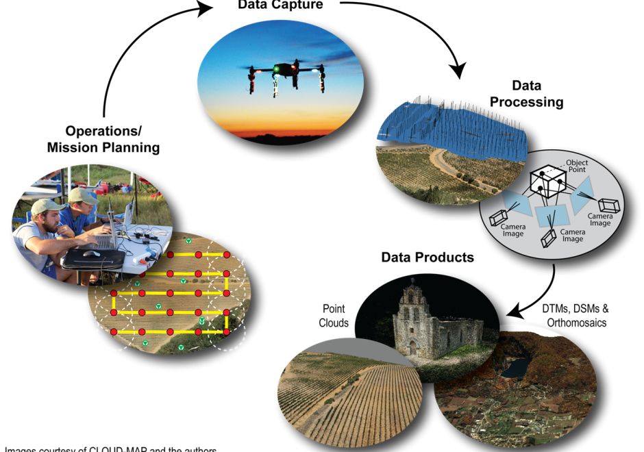
Unmanned Aerial Systems (UAS) are revolutionizing how GIS&T researchers and practitioners model and analyze our world. Compared to traditional remote sensing approaches, UAS provide a largely inexpensive, flexible, and relatively easy-to-use platform to capture high spatial and temporal resolution geospatial data. Developments in computer vision, specifically Structure from Motion (SfM), enable processing of UAS-captured aerial images to produce three-dimensional point clouds and orthophotos. However, many challenges persist, including restrictive legal environments for UAS flight, extensive data processing times, and the need for further basic research. Despite its transformative potential, UAS adoption still faces some societal hesitance due to privacy concerns and liability issues.

DC-14 - Vector data extraction
  • Describe the source data, instrumentation, and workflow involved in extracting vector data (features and elevations) from analog and digital stereoimagery
  • Discuss future prospects for automated feature extraction from aerial imagery
  • Discuss the extent to which vector data extraction from aerial stereoimagery has been automated
DC-29 - Volunteered Geographic Information

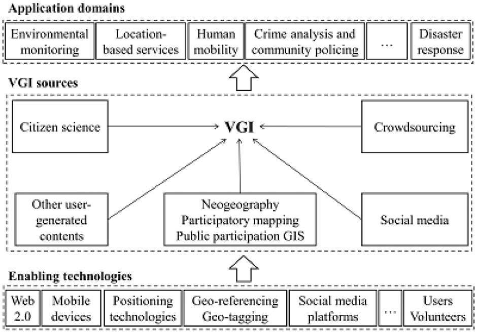
Volunteered geographic information (VGI) refers to geo-referenced data created by citizen volunteers. VGI has proliferated in recent years due to the advancement of technologies that enable the public to contribute geographic data. VGI is not only an innovative mechanism for geographic data production and sharing, but also may greatly influence GIScience and geography and its relationship to society. Despite the advantages of VGI, VGI data quality is under constant scrutiny as quality assessment is the basis for users to evaluate its fitness for using it in applications. Several general approaches have been proposed to assure VGI data quality but only a few methods have been developed to tackle VGI biases. Analytical methods that can accommodate the imperfect representativeness and biases in VGI are much needed for inferential use where the underlying phenomena of interest are inferred from a sample of VGI observations. VGI use for inference and modeling adds much value to VGI. Therefore, addressing the issue of representativeness and VGI biases is important to fulfill VGI’s potential. Privacy and security are also important issues. Although VGI has been used in many domains, more research is desirable to address the fundamental intellectual and scholarly needs that persist in the field.

Pages