basic analytical operations

AM-03 - Buffers

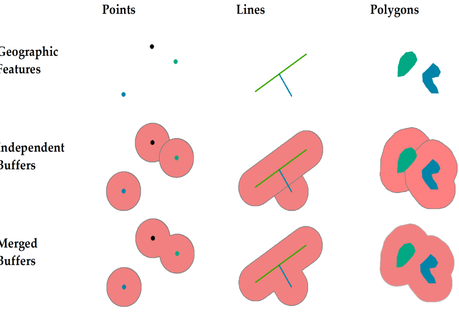
This short article introduces the definition of buffer and explains how buffers are created for single or multiple geographic features of different geometric types. It also discusses how buffers are generated differently in vector and raster data models and based on the concept of cost.
AM-06 - Map algebra
  • Explain the categories of map algebra operations (i.e., local, focal, zonal, and global functions)
  • Explain why georegistration is a precondition to map algebra
  • Differentiate between map algebra and matrix algebra using real examples
  • Perform a map algebra calculation using command line, form-based, and flow charting user interfaces
  • Describe a real modeling situation in which map algebra would be used (e.g., site selection, climate classification, least-cost path)
  • Describe how map algebra performs mathematical functions on raster grids
AM-05 - Neighborhoods
  • Discuss the role of Voronoi polygons as the dual graph of the Delaunay triangulation
  • Explain how Voronoi polygons can be used to define neighborhoods around a set of points
  • Outline methods that can be used to establish non-overlapping neighborhoods of similarity in raster datasets
  • Create proximity polygons (Thiessen/Voronoi polygons) in point datasets
  • Write algorithms to calculate neighborhood statistics (minimum, maximum, focal flow) using a moving window in raster datasets
  • Explain how the range of map algebra operations (local, focal, zonal, and global) relate to the concept of neighborhoods
AM-04 - Overlay
  • Explain why the process “dissolve and merge” often follows vector overlay operations
  • Outline the possible sources of error in overlay operations
  • Compare and contrast the concept of overlay as it is implemented in raster and vector domains
  • Demonstrate how the geometric operations of intersection and overlay can be implemented in GIS
  • Demonstrate why the georegistration of datasets is critical to the success of any map overlay operation
  • Formalize the operation called map overlay using Boolean logic
  • Explain what is meant by the term “planar enforcement”
  • Exemplify applications in which overlay is useful, such as site suitability analysis
AM-03 - Buffers
  • Compare and contrast raster and vector definitions of buffers
  • Outline circumstances in which buffering around an object is useful in analysis
  • Explain why a buffer is a contour on a distance surface

Pages