development

PD-32 - JavaScript for GIS

JavaScript (which has no connection to the Java computer language) is a popular high-level programming languages used to develop user interfaces in web pages. The principle goal of using JavaScript for programming web and mobile GIS applications is to build front-end applications that make use of spatial data and GIS principles, and in many cases, have embedded, interactive maps. It is considered much easier to program than Java or C languages for adding automation, animation, and interactivity into web pages and applications. JavaScript uses the leading browsers as runtime environments (RTE) and thus benefits from rapid and continuously evolving browser support for all web and mobile applications.

PD-16 - Web GIS Programming
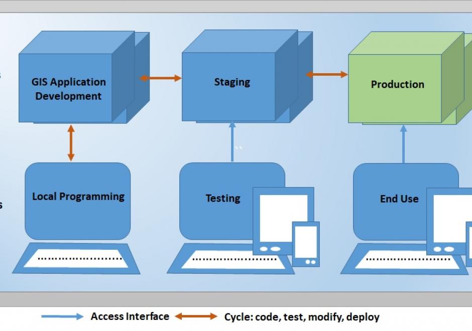
Web GIS programming involves creating, extending, utilizing, Web GIS or web mapping solutions to solve specific problems, build complete applications, or consume or produce data and geospatial processing services. With the expansion of the internet and availability of Web GIS or Web mapping options, web GIS programming is becoming a commonly required skill set in many organizations. Web GIS programming is a type of software development that provides a means of handling internet, browser-based software application development tasks which require unique solutions to web GIS or web mapping problems. In addition, a number of Web GIS software options offer application programming interfaces (APIs) that provide a means by which developers can leverage the published data and processing services of others to build and customize applications through standardized interfaces with external web GIS software, data, and services. Web GIS programming applies to mobile as well as desktop application development. A browser typically runs software applications by submitting Hypertext Transfer Protocol (HTTP) or Hypertext Transfer Protocol Secure (HTTPS) requests to a server hosting resources the application user wishes to access available through a Uniform Resource Locator (URL), and the server replies by providing resources or performing functions requested by the user. This entry reviews the fundamentals of web GIS programming, accompanying the Web Mapping and other entries in the Programming and Development section, the Web GIS entry in the Computing Platforms section, and the User Interface and User Experience (UI/UX) Design entry in the Cartography and Visualization section (Sack, 2017; Quinn, 2018; Roth, 2017).

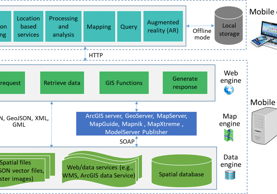
PD-29 - Programming of Mobile GIS Applications

Mobile technology has significantly changed how we communicate and interact with the outside world. With the increasing use of mobile devices and advancement of information communication information (ICT) technologies, mobile GIS emerged to provide real-time data collection and update, and made GIS easier and convenient to access. This entry introduces the concept, types, and general architecture of mobile GIS, key technologies used for mobile GIS development, and examples of mobile GIS applications.

PD-11 - Python for GIS

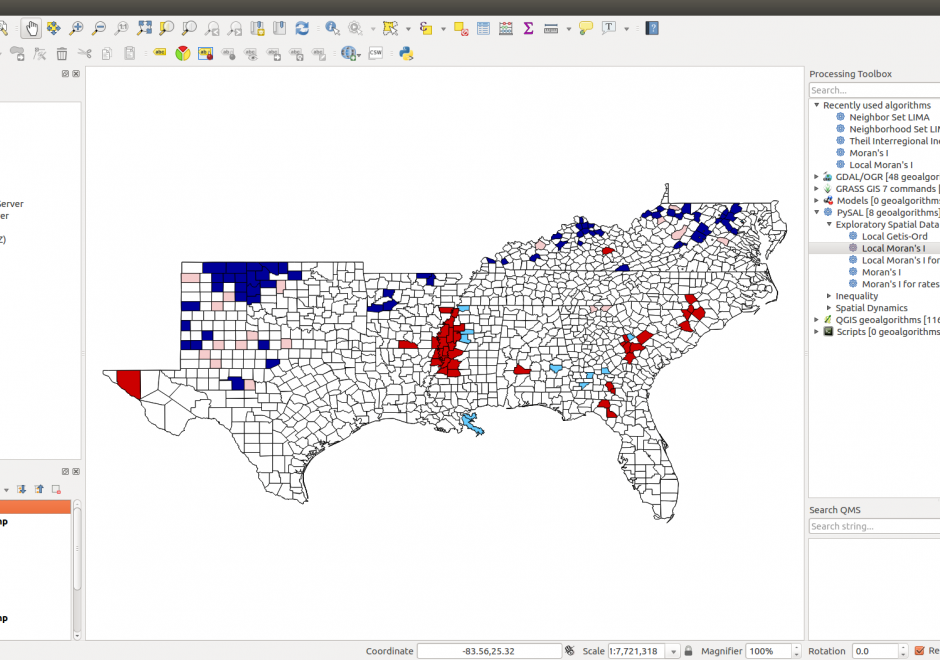
Figure 1. PySAL within QGIS Processing Toolbox: Hot-spot analysis of Homicide Rates in Southern US Counties.


Python is a popular language for geospatial programming and application development. This entry provides an overview of the different development modes that can be adopted for GIS programming with Python and discusses the history of Python adoption in the GIS community. The different layers of the geospatial development stack in Python are examined giving the reader an understanding of the breadth that Python offers to the GIS developer. Future developments and broader issues related to interoperability and programming ecosystems are identified.

PD-32 - JavaScript for GIS

JavaScript (which has no connection to the Java computer language) is a popular high-level programming languages used to develop user interfaces in web pages. The principle goal of using JavaScript for programming web and mobile GIS applications is to build front-end applications that make use of spatial data and GIS principles, and in many cases, have embedded, interactive maps. It is considered much easier to program than Java or C languages for adding automation, animation, and interactivity into web pages and applications. JavaScript uses the leading browsers as runtime environments (RTE) and thus benefits from rapid and continuously evolving browser support for all web and mobile applications.

PD-16 - Web GIS Programming

Web GIS programming involves creating, extending, utilizing, Web GIS or web mapping solutions to solve specific problems, build complete applications, or consume or produce data and geospatial processing services. With the expansion of the internet and availability of Web GIS or Web mapping options, web GIS programming is becoming a commonly required skill set in many organizations. Web GIS programming is a type of software development that provides a means of handling internet, browser-based software application development tasks which require unique solutions to web GIS or web mapping problems. In addition, a number of Web GIS software options offer application programming interfaces (APIs) that provide a means by which developers can leverage the published data and processing services of others to build and customize applications through standardized interfaces with external web GIS software, data, and services. Web GIS programming applies to mobile as well as desktop application development. A browser typically runs software applications by submitting Hypertext Transfer Protocol (HTTP) or Hypertext Transfer Protocol Secure (HTTPS) requests to a server hosting resources the application user wishes to access available through a Uniform Resource Locator (URL), and the server replies by providing resources or performing functions requested by the user. This entry reviews the fundamentals of web GIS programming, accompanying the Web Mapping and other entries in the Programming and Development section, the Web GIS entry in the Computing Platforms section, and the User Interface and User Experience (UI/UX) Design entry in the Cartography and Visualization section (Sack, 2017; Quinn, 2018; Roth, 2017).
PD-29 - Programming of Mobile GIS Applications

Mobile technology has significantly changed how we communicate and interact with the outside world. With the increasing use of mobile devices and advancement of information communication information (ICT) technologies, mobile GIS emerged to provide real-time data collection and update, and made GIS easier and convenient to access. This entry introduces the concept, types, and general architecture of mobile GIS, key technologies used for mobile GIS development, and examples of mobile GIS applications.

PD-11 - Python for GIS

Figure 1. PySAL within QGIS Processing Toolbox: Hot-spot analysis of Homicide Rates in Southern US Counties.


Python is a popular language for geospatial programming and application development. This entry provides an overview of the different development modes that can be adopted for GIS programming with Python and discusses the history of Python adoption in the GIS community. The different layers of the geospatial development stack in Python are examined giving the reader an understanding of the breadth that Python offers to the GIS developer. Future developments and broader issues related to interoperability and programming ecosystems are identified.

PD-32 - JavaScript for GIS

JavaScript (which has no connection to the Java computer language) is a popular high-level programming languages used to develop user interfaces in web pages. The principle goal of using JavaScript for programming web and mobile GIS applications is to build front-end applications that make use of spatial data and GIS principles, and in many cases, have embedded, interactive maps. It is considered much easier to program than Java or C languages for adding automation, animation, and interactivity into web pages and applications. JavaScript uses the leading browsers as runtime environments (RTE) and thus benefits from rapid and continuously evolving browser support for all web and mobile applications.

PD-16 - Web GIS Programming

Web GIS programming involves creating, extending, utilizing, Web GIS or web mapping solutions to solve specific problems, build complete applications, or consume or produce data and geospatial processing services. With the expansion of the internet and availability of Web GIS or Web mapping options, web GIS programming is becoming a commonly required skill set in many organizations. Web GIS programming is a type of software development that provides a means of handling internet, browser-based software application development tasks which require unique solutions to web GIS or web mapping problems. In addition, a number of Web GIS software options offer application programming interfaces (APIs) that provide a means by which developers can leverage the published data and processing services of others to build and customize applications through standardized interfaces with external web GIS software, data, and services. Web GIS programming applies to mobile as well as desktop application development. A browser typically runs software applications by submitting Hypertext Transfer Protocol (HTTP) or Hypertext Transfer Protocol Secure (HTTPS) requests to a server hosting resources the application user wishes to access available through a Uniform Resource Locator (URL), and the server replies by providing resources or performing functions requested by the user. This entry reviews the fundamentals of web GIS programming, accompanying the Web Mapping and other entries in the Programming and Development section, the Web GIS entry in the Computing Platforms section, and the User Interface and User Experience (UI/UX) Design entry in the Cartography and Visualization section (Sack, 2017; Quinn, 2018; Roth, 2017).

Pages