
DA-25 - Geospatial Intelligence and National Security

GIS&T exists within the national security enterprise as a multidisciplinary field that is now commonly referred to as Geospatial Intelligence (GEOINT). U.S. GEOINT operations are principally managed by the National Geospatial-Intelligence Agency (NGA). GEOINT is one among several types of intelligence produced in support of national security, along with Human Intelligence (HUMINT), Signals Intelligence (SIGINT), Measurement and Signatures Intelligence (MASINT), and Open Source Intelligence (OSINT). Primary technical GEOINT skill areas include remote sensing, GIS, data management, and data visualization. The intelligence tradecraft is historically characterized as a process involving tasking, collection, processing, exploitation, and dissemination (TCPED), and supports decision-making for military, defense, and intelligence operations. The GEOINT enterprise utilizes every type of data collection platform, sensor, and imagery to develop intelligence reports. GEOINT products are used to support situational awareness, safety of navigation, arms control treaty monitoring, natural disaster response, and humanitarian relief operations. Geospatial analysts employed in government positions by NGA or serving in the U.S. armed forces are required to qualify in NGA’s GEOINT Professional Certification (GPC) program, and industry contractors have the option of qualifying under the United States Geospatial Intelligence Foundation (USGIF) Certified GEOINT Professional (CGP) program.


")
")
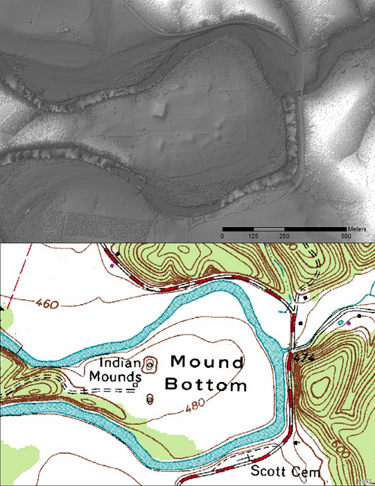
DC-27 - Light Detection and Ranging (LiDAR)
LiDAR (Light Detection and Ranging) is a remote sensing technology that collects information reflected or refracted from the Earth’s surface. The instrumentation that collects LiDAR data can be housed on drones, airplanes, helicopters, or satellites, and consists of a laser scanner that transmits pulses of light. These transmitted pulses reflect or refract from objects on the Earth’s surface or from the surface itself, and the time delay is recorded. Knowing the travel time and the speed of light, an elevation of each pulse above the surface can be determined. From the pulse data collected, the user can determine the topography and landscape features of the Earth or whatever surface has received the pulses. The evolution of software that displays and analyzes LiDAR data and the development of new and more compact file formats have allowed the use of LiDAR to grow dramatically in recent years.