
DA-08 - GIS&T and Archaeology

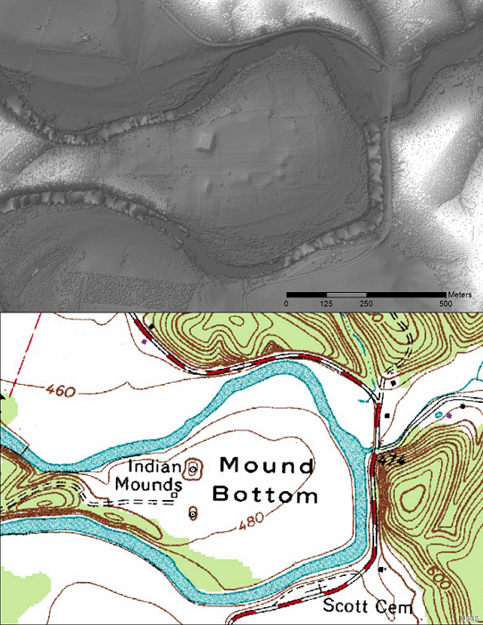
Figure 1. USGS topo map and bare earth (LiDAR) image of Tennessee’s Mound Bottom State Archaeological Area. Bare Earth DEM processed by Zada Law.
Archaeology provides a glimpse into the lives of past peoples and histories that may have otherwise been forgotten. Geographic Information Systems and Technology (GIS&T) has become an invaluable tool in this endeavor by advancing the identification, documentation, and study of archaeological resources. Large scale mapping techniques have increased the efficiency of site surveys even in challenging environments. GIS&T refers to such things as remote sensing, spatial analysis, and mapping tools. The use of GIS&T for archaeology is a truly interdisciplinary field as it borrows principles from geology, oceanography, botany, meteorology and more in order to further the science. This chapter discusses some of the primary GIS&T tools and techniques used in archaeology and the primary ways in which they are applied.


DA-01 - GIS&T and Agriculture
Agriculture, whether in the Corn Belt of the United States, the massive rice producing areas of Southeast Asia, or the bean harvest of a smallholder producer in Central America, is the basis for feeding the world. Agriculture systems are highly complex and heterogeneous in both space and time. The need to contextualize this complexity and to make more informed decisions regarding agriculture has led to GIS&T approaches supporting the agricultural sciences in many different areas. Agriculture represents a rich resource of spatiotemporal data and different problem contexts; current and future GIScientists should look toward agricultural as a potentially rewarding area of investigation and, likewise, one where new approaches have the potential to help improve the food, environmental, and economic security of people around the world.