2018 QUARTER 03

A B C D E F G H I K L M N O P R S T U V W
AM-10 - Spatial Interaction

Spatial interaction (SI) is a fundamental concept in the GIScience literature, and may be defined in numerous ways. SI often describes the "flow" of individuals, commodities, capital, and information over (geographic) space resulting from a decision process. Alternatively, SI is sometimes used to refer to the influence of spatial proximity of places on the intensity of relations between those places. SI modeling as a separate research endeavor developed out of a need to mathematically model and understand the underlying determinants of these flows/influences. Proponents of SI modeling include economic geographers, regional scientists, and regional planners, as well as climate scientists, physicists, animal ecologists, and even some biophysical/environmental researchers. Originally developed from theories of interacting particles and gravitational forces in physics, SI modeling has developed through a series of refinements in terms of functional form, conceptual representations of distances, as well as a range of analytically rigorous technical improvements.
 

CP-07 - Spatial MapReduce
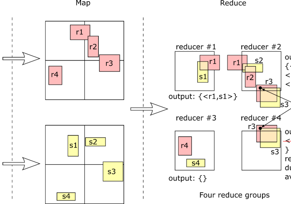
MapReduce has become a popular programming paradigm for distributed processing platforms. It exposes an abstraction of two functions, map and reduce, which users can define to implement a myriad of operations. Once the two functions are defined, a MapReduce framework will automatically apply them in parallel to billions of records and over hundreds of machines. Users in different domains are adopting MapReduce as a simple solution for big data processing due to its flexibility and efficiency. This article explains the MapReduce programming paradigm, focusing on its applications in processing big spatial data. First, it gives a background on MapReduce as a programming paradigm and describes how a MapReduce framework executes it efficiently at scale. Then, it details the implementation of two fundamental spatial operations, namely, spatial range query and spatial join. Finally, it gives an overview of spatial indexing in MapReduce systems and how they can be combined with MapReduce processing.

AM-14 - Spatial process models
  • Discuss the relationship between spatial processes and spatial patterns
  • Differentiate between deterministic and stochastic spatial process models
  • Describe a simple process model that would generate a given set of spatial patterns
FC-13 - Spatial queries
  • Demonstrate the syntactic structure of spatial and temporal operators in SQL
  • State questions that can be solved by selecting features based on location or spatial relationships
  • Construct a query statement to search for a specific spatial or temporal relationship
  • Construct a spatial query to extract all point objects that fall within a polygon
  • Compare and contrast attribute query and spatial query
DC-07 - Spatial sample types
  • Design point, transect, and area sampling strategies for given applications
  • Differentiate between situations in which one would use stratified random sampling and systematic sampling
  • Differentiate among random, systematic, stratified random, and stratified systematic unaligned sampling strategies
AM-26 - Spatial sampling for statistical analysis
  • List and describe several spatial sampling schemes and evaluate each one for specific applications
  • Differentiate between model-based and design-based sampling schemes
  • Design a sampling scheme that will help detect when space-time clusters of events occur
  • Create spatial samples under a variety of requirements, such as coverage, randomness, and transects
  • Describe sampling schemes for accurately estimating the mean of a spatial data set
DM-18 - Spatio-temporal GIS
  • Describe extensions to relational DBMS to represent temporal change in attributes
  • Evaluate the advantages and disadvantages of existing space-time models based on storage efficiency, query performance, ease of data entry, and ability to implement in existing software
  • Create a GIS database that models temporal information
  • Utilize two different space-time models to characterize a given scenario, such as a daily commute
  • Describe the architecture of data models (both field and object based) to represent spatio-temporal phenomena
  • Differentiate the two types of temporal information to be modeled in databases: database (or transaction) time and valid (or world) time
  • Identify whether it is important to represent temporal change in a particular GIS application
  • Describe SQL extensions for querying temporal change
DC-23 - State and regional coordinating bodies
  • Describe how state GIS councils can be used in enterprise GIS&T implementation processes
  • Explain the functions, mission, history, constituencies, and activities of your state GIS Council and related formal and informal bodies
  • Discuss how informal and formal regional bodies (e.g., Metro GIS) can help support GIS&T in an organization
  • Discuss the mission, history, constituencies, and activities of National States Geographic Information Council (NSGIC)
  • Determine if your state has a Geospatial Information Office (GIO) and discuss the mission, history, constituencies, and activities of a GIO
CV-05 - Statistical Mapping (Enumeration, Normalization, Classification, Dasymetric)
  • Discuss advantages and disadvantages of various data classification methods for choropleth mapping, including equal interval, quantiles, mean-standard deviation, natural breaks, and “optimal” methods
  • Demonstrate how different classification schemes produce very different maps from a single set of interval- or ratio-level data
  • Write algorithms to perform equal interval, quantiles, mean-standard deviation, natural breaks, and “optimal” classification for choropleth mapping
DC-13 - Stereoscopy and orthoimagery
  • Explain the relevance of the concept “parallax” in stereoscopic aerial imagery
  • Evaluate the advantages and disadvantages of photogrammetric methods and LiDAR for production of terrain elevation data
  • Specify the technical components of an aerotriangulation system
  • Outline the sequence of tasks involved in generating an orthoimage from a vertical aerial photograph

Pages