Search Page

Showing 1 - 6 of 6
KE-31 - Professional Certification

Professional Certification has been a part of the GIS enterprise for over two decades. There are several different certification programs and related activities now in operation within GIS, though there has been much debate over its merits, how it should be done and by whom. 

KE-19 - Managing GIS&T Operations and Infrastructure
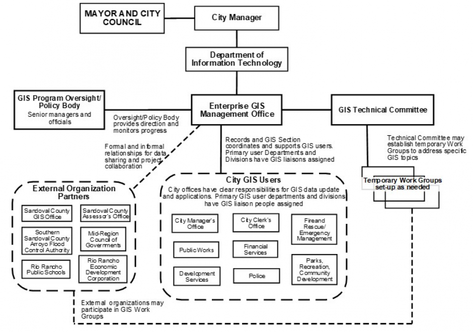
This article discusses the key role of effective management practices to derive expected benefits from the infrastructure and operations of enterprise GIS, including needs assessment, data evaluation and management, and stakeholder involvement. It outlines management factors related to an emerging application of enterprise GIS.  How to configure GIS infrastructure and operations to support enterprise business needs is the focus. When appropriate, additional information is provided for programs, projects, and activities specifically relevant for equity and social justice.

KE-32 - Competence in GIS&T Knowledge Work

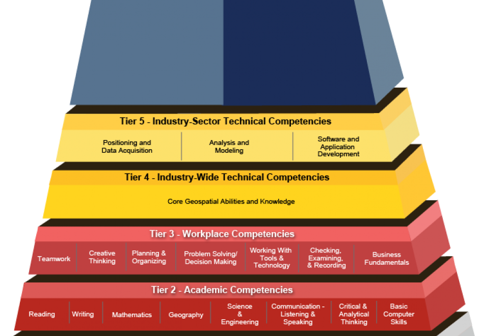
“Competence” is a word that rolls off the tongues of instructional designers, education administrators, and HR people. Others find it hard to swallow. For some GIS&T educators, competence connotes an emphasis on vocational instruction that’s unworthy of the academy. This entry challenges skeptical educators to rethink competence not just as readiness for an occupation, but first and foremost as the readiness to live life to the fullest, and to contribute to a sustainable future. The entry considers the OECD’s “Key Competencies for a Successful Life and Well-Functioning Society,” as well as the specialized GIS&T competencies specified in the U.S. Department of Labor’s Geospatial Technology Competency Model. It presents findings of a survey in which 226 self-selected members of Esri’s Young Professionals Network observe that competencies related to the GTCM’s Software and App Development Segment were under-developed in their university studies. Looking ahead, in the context of an uncertain future in which, some say, many workers are at risk of “technological unemployment,” the entry considers which GIS&T competencies are likely to be of lasting value.

CP-26 - eScience, the Evolution of Science

Science—and research more broadly—face many challenges as its practitioners struggle to accommodate new challenges around reproducibility and openness.  The current practice of science limits access to knowledge, information and infrastructure, which in turn leads to inefficiencies, frustrations and a lack of rigor.  Many useful research outcomes are never used because they are too difficult to find, or to access, or to understand.

New computational methods and infrastructure provide opportunities to reconceptualize how science is conducted, how it is shared, how it is evaluated and how it is reused.  And new data sources changed what can be known, and how well, and how frequently.  This article describes some of the major themes of eScience/eResearch aimed at improving the process of doing science.

CP-15 - Mobile Devices

Mobile devices refer to a computing system intended to be used by hand, such as smartphones or tablet computers. Mobile devices more broadly refer to mobile sensors and other hardware that has been made for relatively easy transportability, including wearable fitness trackers. Mobile devices are particularly relevant to Geographic Information Systems and Technology (GIS&T) in that they house multiple locational sensors that were until recently very expensive and only accessible to highly trained professionals. Now, mobile devices serve an important role in computing platform infrastructure and are key tools for collecting information and disseminating information to, from, and among heterogeneous and spatially dispersed audiences and devices. Due to the miniaturization and the decrease in the cost of computing capabilities, there has been widespread social uptake of mobile devices, making them ubiquitous. Mobile devices are embedded in Geographic Information Science (GIScience) meaning GIScience is increasingly permeating lived experiences and influencing social norms through the use of mobile devices. In this entry, locational sensors are described, with computational considerations specifically for mobile computing. Mobile app development is described in terms of key considerations for native versus cross-platform development. Finally, mobile devices are contextualized within computational infrastructure, addressing backend and frontend considerations.

KE-33 - Organizational Models for GIS Management

Organizational structures and management practices for GIS programs are numerous and complex. This topic begins with an explanation of organizational and management concepts and context that are particularly relevant to GIS program and project management, including strategic planning and stakeholders. Specific types of organizations that typically use GIS technology are described and organizational structure types are explained. For GIS Program management, organizational placement, organizational components, and management control and policies are covered in depth. Multi-organizational GIS Programs are also discussed. Additional topics include management roles and technology trends that affect organizational structure. It concludes with a general description of GIS Project management.