Search Page

Showing 1 - 5 of 5
CV-19 - Big Data Visualization

As new information and communication technologies have altered so many aspects of our daily lives over the past decades, they have simultaneously stimulated a shift in the types of data that we collect, produce, and analyze. Together, this changing data landscape is often referred to as "big data." Big data is distinguished from "small data" not only by its high volume but also by the velocity, variety, exhaustivity, resolution, relationality, and flexibility of the datasets. This entry discusses the visualization of big spatial datasets. As many such datasets contain geographic attributes or are situated and produced within geographic space, cartography takes on a pivotal role in big data visualization. Visualization of big data is frequently and effectively used to communicate and present information, but it is in making sense of big data – generating new insights and knowledge – that visualization is becoming an indispensable tool, making cartography vital to understanding geographic big data. Although visualization of big data presents several challenges, human experts can use visualization in general, and cartography in particular, aided by interfaces and software designed for this purpose, to effectively explore and analyze big data.

CP-26 - eScience, the Evolution of Science
Science—and research more broadly—face many challenges as its practitioners struggle to accommodate new challenges around reproducibility and openness.  The current practice of science limits access to knowledge, information and infrastructure, which in turn leads to inefficiencies, frustrations and a lack of rigor.  Many useful research outcomes are never used because they are too difficult to find, or to access, or to understand.

New computational methods and infrastructure provide opportunities to reconceptualize how science is conducted, how it is shared, how it is evaluated and how it is reused.  And new data sources changed what can be known, and how well, and how frequently.  This article describes some of the major themes of eScience/eResearch aimed at improving the process of doing science.

CP-15 - Mobile Devices

Mobile devices refer to a computing system intended to be used by hand, such as smartphones or tablet computers. Mobile devices more broadly refer to mobile sensors and other hardware that has been made for relatively easy transportability, including wearable fitness trackers. Mobile devices are particularly relevant to Geographic Information Systems and Technology (GIS&T) in that they house multiple locational sensors that were until recently very expensive and only accessible to highly trained professionals. Now, mobile devices serve an important role in computing platform infrastructure and are key tools for collecting information and disseminating information to, from, and among heterogeneous and spatially dispersed audiences and devices. Due to the miniaturization and the decrease in the cost of computing capabilities, there has been widespread social uptake of mobile devices, making them ubiquitous. Mobile devices are embedded in Geographic Information Science (GIScience) meaning GIScience is increasingly permeating lived experiences and influencing social norms through the use of mobile devices. In this entry, locational sensors are described, with computational considerations specifically for mobile computing. Mobile app development is described in terms of key considerations for native versus cross-platform development. Finally, mobile devices are contextualized within computational infrastructure, addressing backend and frontend considerations.

CV-01 - Cartography and Science

"Science" is used both to describe a general, systematic approach to understanding the world and to refer to that approach as it is applied to a specific phenomenon of interest, for example, "geographic information science." The scientific method is used to develop theories that explain phenomena and processes. It consists of an iterative cycle of several steps: proposing a hypothesis, devising a way to make empirical observations that test that hypothesis, and finally, refining the hypothesis based on the empirical observations. "Scientific cartography" became a dominant mode of cartographic research and inquiry after World War II, when there was increased focus on the efficacy of particular design decisions and how particular maps were understood by end users. This entry begins with a brief history of the development of scientific cartographic approaches, including how they are deployed in map design research today. Next it discusses how maps have been used by scientists to support scientific thinking. Finally, it concludes with a discussion of how maps are used to communicate the results of scientific thinking.

CV-26 - Cartography and Power

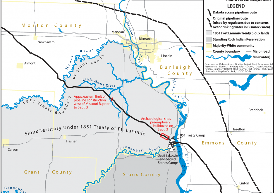
Over twenty five years ago, Brian Harley (1989, p. 2) implored cartographers to “search for the social forces that have structured cartography and to locate the presence of power – and its effects – in all map knowledge.” In the intervening years, while Harley has become a bit of a touchstone for citational practices acknowledging critical cartography (Edney, 2015), both theoretical understandings of power as well as the tools and technologies that go into cartographic production have changed drastically. This entry charts some of the many ways that power may be understood to manifest within and through maps and mapmaking practices. To do so, after briefly situating work on cartography and power historically, it presents six critiques of cartography and power in the form of dialectics. First, building from Harley’s earlier work, it defines a deconstructivist approach to mapping and places it in contrast to hermeneutic phenomenological approaches. Second, it places state-sanctioned practices of mapping against participatory and counter-mapping ones. Third, epistemological understanding of maps and their affects are explored through the dialectic of the map as a static object versus more processual, ontogenetic understandings of maps. Finally, the chapter concludes by suggesting the incomplete, heuristic nature of both the approaches and ideas explored here as well as the practices of critical cartography itself. Additional resources for cartographers and GIScientists seeking to further explore critical approaches to maps are provided.