2017 QUARTER 03

A B C D E F G H I K L M N O P R S T U V W
FC-29 - Public sector origins
  • Identify some of the key federal agencies and programs that provided the impetus for the development of GIS&T
  • Explain how the federalization of land management in Canada led to the development of the Canadian Geographic Information System in the 1960s
  • Discuss the role of the U.S. Census Bureau in contributing to the development of the U.S. geospatial industry
  • Discuss the role of the U.S. Geological Survey in contributing to the development of the U.S. geospatial industry
  • Describe the mechanical and computerized technologies used by civilian and military mapping agencies between World War II and the advent of GIS
  • Trace the history of the relationship between the intelligence community and the geospatial industry
  • Compare and contrast the initiatives of various countries to move their national mapping activities to geospatial data
  • Describe the role of NASA and the Landsat program in promoting development of digital image processing and raster GIS systems
KE-28 - Publications
  • Describe the leading academic journals serving the GIS&T community
  • Select association and for-profit journals that are useful to entities managing enterprise GISs
  • Select and describe the leading trade journals serving the GIS&T community
  • Develop a bibliography of scholarly and professional articles and/or books that are relevant to a particular GIS&T project
PD-11 - Python for GIS

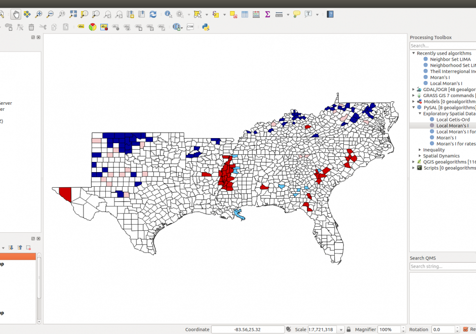
Figure 1. PySAL within QGIS Processing Toolbox: Hot-spot analysis of Homicide Rates in Southern US Counties.


Python is a popular language for geospatial programming and application development. This entry provides an overview of the different development modes that can be adopted for GIS programming with Python and discusses the history of Python adoption in the GIS community. The different layers of the geospatial development stack in Python are examined giving the reader an understanding of the breadth that Python offers to the GIS developer. Future developments and broader issues related to interoperability and programming ecosystems are identified.

CV-20 - Raster Formats and Sources
  • Explain how color fastness and color consistency are ensured in map production
  • Compare outputs of the same map at various low and high resolutions
  • Differentiate among the various raster map outputs (JPEG, GIF, TIFF) and various vector formats (PDF, Adobe Illustrator Postscript)
  • Compare and contrast the file formats suited to presentation of maps on the Web to those suited to publication in high resolution contexts
  • Compare and contrast the issues that arise for map production using black-and-white and fourcolor process specifications
  • Outline the process for the digital production of offset press printed maps, including reference to feature and color separates, feature and map composites, and resolution
  • Critique typographic integrity in export formats (e.g., some file export processes break type into letters degrading searchability, font processing, and reliability of Raster Image Processing)
  • Prepare a map file for CMYK publication in a book
  • Prepare a map file for RGB presentation on a Web site
  • Discuss the purpose of advanced production methods (e.g., stochastic screening, hexachrome color, color management and device profiles, trapping, overprinting)
AM-60 - Raster resampling
  • Evaluate methods used by contemporary GIS software to resample raster data on-the-fly during display
  • Select appropriate interpolation techniques to resample particular types of values in raster data (e.g., nominal using nearest neighbor)
  • Resample multiple raster data sets to a single resolution to enable overlay
  • Resample raster data sets (e.g., terrain, satellite imagery) to a resolution appropriate for a map of a particular scale
  • Discuss the consequences of increasing and decreasing resolution
DM-39 - Reconciling database change
  • Design a test of reliability of change information (e.g., the logical consistency of updates to the TIGER database)
  • Implement a test of reliability of change information
DM-03 - Relational DBMS
  • Explain the advantage of the relational model over earlier database structures including spreadsheets
  • Define the basic terms used in relational database management systems (e.g., tuple, relation, foreign key, SQL, relational join)
  • Discuss the efficiency and costs of normalization
  • Describe the entity-relationship diagram approach to data modeling
  • Explain how entity-relationship diagrams are translated into relational tables
  • Create an SQL query that extracts data from related tables
  • Describe the problems associated with failure to follow the first and second normal forms (including data confusion, redundancy, and retrieval difficulties)
  • Demonstrate how search and relational join operations provide results for a typical GIS query and other simple operations using the relational DBMS within a GIS software application
FC-09 - Relationships between space and time
  • Discuss common prepositions and adjectives (in any particular language) that signify either spatial or temporal relations but are used for both kinds, such as “after” or “longer”
  • Describe different types of movement and change
  • Understand the physical notions of velocity and acceleration which are fundamentally about movement across space through time
  • Identify various types of geographic interactions in space and time
  • Compare and contrast the characteristics of spatial and temporal dimensions
KE-05 - Requirements analysis
  • Describe the need for user-centered requirements analysis
  • Create requirements reports for individual potential applications in terms of the data, procedures, and output needed
  • Assess the relative importance and immediacy of potential applications
  • Synthesize the needs of individual users and tasks into enterprise-wide needs
  • Differentiate between the responsibilities of the proposed system and those that remain with the user
  • Illustrate how a business process analysis can be used to identify requirements during a GIS implementation
  • Describe how spatial data and GIS&T can be integrated into a workflow process
  • Evaluate how external spatial data sources can be incorporated into the business process
  • Develop use cases for potential applications using established techniques with potential users, such as questionnaires, interviews, focus groups, the Delphi method, and/or joint application development (JAD)
  • Document existing and potential tasks in terms of workflow and information flow
FC-21 - Resolution
  • Illustrate and explain the distinction between resolution, precision, and accuracy
  • Discuss the implications of the sampling theorem (? = 0.5 d) to the concept of resolution
  • Differentiate among the spatial, spectral, radiometric, and temporal resolution of a remote sensing instrument
  • Explain how resampling affects the resolution of image data
  • Discuss the advantages and potential problems associated with the use of minimum mapping unit (MMU) as a measure of the level of detail in land use, land cover, and soils maps
  • Illustrate and explain the distinctions between spatial resolution, thematic resolution, and temporal resolution
  • Illustrate the impact of grid cell resolution on the information that can be portrayed
  • Relate the concept of grid cell resolution to the more general concept of “support” and granularity
  • Evaluate the implications of changing grid cell resolution on the results of analytical applications by using GIS software
  • Evaluate the ease of measuring resolution in different types of tessellations

Pages