2018 QUARTER 01

A B C D E F G H I K L M N O P R S T U V W
AM-05 - Neighborhoods
  • Discuss the role of Voronoi polygons as the dual graph of the Delaunay triangulation
  • Explain how Voronoi polygons can be used to define neighborhoods around a set of points
  • Outline methods that can be used to establish non-overlapping neighborhoods of similarity in raster datasets
  • Create proximity polygons (Thiessen/Voronoi polygons) in point datasets
  • Write algorithms to calculate neighborhood statistics (minimum, maximum, focal flow) using a moving window in raster datasets
  • Explain how the range of map algebra operations (local, focal, zonal, and global) relate to the concept of neighborhoods
FC-19 - Networks defined
  • Define different interpretations of “cost” in various routing applications
  • Describe networks that apply to specific applications or industries
  • Create a data set with network attributes and topology
  • Define the following terms pertaining to a network: Loops, multiple edges, the degree of a vertex, walk, trail, path, cycle, fundamental cycle
AM-63 - Non-linearity relationships and non-Gaussian distributions
  • Understand how some machine learning methods might be more adept at modeling or representing such distributions
  • Define non-linear and non-Gaussian distributions in a geospatial data environment
  • Exemplify non-linear and non-Gaussian distributions in a geospatial data environment
DM-17 - Object-based spatial databases
  • Discuss the merits of storing geometric data in the same location as attribute data
  • Evaluate the advantages and disadvantages of the object-based data model compared to the layer-based vector data model (topological or spaghetti)
  • Describe the architectures of various object-relational spatial data models, including spatial extensions of DBMS, proprietary object-based data models from GIS vendors, and open-source and standards-based efforts
  • Differentiate between the topological vector data model and spaghetti object data with topological rulebases
  • Write a script (in a GIS, database, or Web environment) to read and write data in an objectbased spatial database
  • Transfer geospatial data from an XML schema to a database
  • Discuss the degree to which various object-relational spatial data models approximate a true object-oriented paradigm, and whether they should
DM-04 - Object-oriented DBMS
  • Describe the basic elements of the object-oriented paradigm, such as inheritance, encapsulation, methods, and composition
  • Evaluate the degree to which the object-oriented paradigm does or does not approximate cognitive structures
  • Explain how the principle of inheritance can be implemented using an object-oriented programming approach
  • Defend or refute the notion that the Extensible Markup Language (XML) is a form of object-oriented database
  • Explain how the properties of object orientation allows for combining and generalizing objects
  • Evaluate the advantages and disadvantages of object-oriented databases compared to relational databases, focusing on representational power, data entry, storage efficiency, and query performance
  • Implement a GIS database design in an off-the-shelf, object-oriented database
  • Differentiate between object-oriented programming and object-oriented databases
DM-61 - Ongoing GIS revision
  • Describe a method that allows users within an organization to access data, including methods of data sharing, version control, and maintenance
  • Describe how spatial data and GIS&T can be integrated into a work flow process
  • Develop a plan for user feedback and self-evaluation procedures
  • Evaluate how external spatial data sources can be incorporated into the business process
  • Evaluate internal spatial databases for continuing adequacy
  • Evaluate the efficiency and effectiveness of an existing enterprise GIS
  • Evaluate the needs for spatial data sources including currency, accuracy and access, specifically addressing issues related to financial costs, sharing arrangements, online/realtime, and transactional processes across an organization
  • Illustrate how a business process analysis can be used to periodically review system requirements
  • List improvements that may be made to the design of an existing GIS
  • Describe how internal spatial data sources can be handled during an implementation process
FC-35 - Openness

The philosophy of Openness and its use in diverse areas is attracting increasing attention from users, developers, businesses, governments, educators, and researchers around the world. The technological, socio-cultural, economic, legal, institutional, and philosophical issues related to its principles, applications, benefits, and barriers for its use are growing areas of research. The word “Open” is commonly used to denote adherence to the principles of Openness. Several fields are incorporating the use of Openness in their activities, some of them are of particular relevance to GIS&T (Geographic Information Science and Technology) such as: Open Data, Free and Open Source Software; and Open Standards for geospatial data, information, and technologies. This entry presents a definition of Openness, its importance in the area of GISc&T is introduced through a list of its benefits in the fields of Open Data, Open Source Software, and Open Standards. Then some of the barriers, myths, or inhibitors to Openness are presented using the case of Free and Open Source Software (FOSS) and FOSS for Geospatial Applications (FOSS4G).

FC-34 - Organizational models for coordinating GISs and/or program participants and stakeholders
  • Compare and contrast centralized, federated, and distributed models for managing information infrastructures
  • Describe the roles and relationships of GIS&T support staff
  • Exemplify how to make GIS&T relevant to top management
  • Describe different organizational models for coordinating GIS&T participants and stakeholders
  • Describe the stages of two different models of implementing a GIS within an organization
FC-33 - Organizational Models for GIS Management

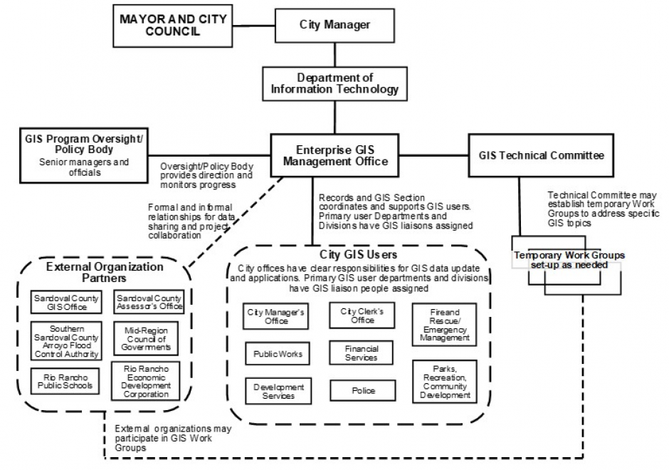
Organizational structures and management practices for GIS programs are numerous and complex. This topic begins with an explanation of organizational and management concepts and context that are particularly relevant to GIS program and project management, including strategic planning and stakeholders. Specific types of organizations that typically use GIS technology are described and organizational structure types are explained. For GIS Program management, organizational placement, organizational components, and management control and policies are covered in depth. Multi-organizational GIS Programs are also discussed. Additional topics include management roles and technology trends that affect organizational structure. It concludes with a general description of GIS Project management. 

AM-43 - Other classic network problems
  • Describe several classic problems to which network analysis is applied (e.g., the traveling salesman problem, the Chinese postman problem)
  • Explain why heuristic solutions are generally used to address the combinatorially complex nature of these problems and the difficulty of solving them optimally

Pages