Domains of geographic information

FC-07 - Space
  • Differentiate between absolute and relative descriptions of location
  • Define the four basic dimensions or shapes used to describe spatial objects (i.e., points, lines, regions, volumes)
  • Discuss the contributions that different perspectives on the nature of space bring to an understanding of geographic phenomenon
  • Justify the discrepancies between the nature of locations in the real world and representations thereof (e.g., towns as points)
  • Select appropriate spatial metaphors and models of phenomena to be represented in GIS
  • Develop methods for representing non-cartesian models of space in GIS
  • Discuss the advantages and disadvantages of the use of cartesian/metric space as a basis for GIS and related technologies
  • Differentiate between common-sense, Cartesian/metric, relational, relativistic, phenomenological, social constructivist, and other theories of the nature of space
FC-09 - Relationships between space and time
  • Discuss common prepositions and adjectives (in any particular language) that signify either spatial or temporal relations but are used for both kinds, such as “after” or “longer”
  • Describe different types of movement and change
  • Understand the physical notions of velocity and acceleration which are fundamentally about movement across space through time
  • Identify various types of geographic interactions in space and time
  • Compare and contrast the characteristics of spatial and temporal dimensions
FC-10 - Properties
  • Formalize attribute values and domains in terms of set theory
  • Develop alternative forms of representations for situations in which attributes do not adequately capture meaning
  • Define Stevens’ four levels of measurement (i.e., nominal, ordinal, interval, ratio)
  • Describe particular geographic phenomena in terms of attributes
  • Determine the proper uses of attributes based on their domains
  • Characterize the domains of attributes in a GIS, including continuous and discrete, qualitative and quantitative, absolute and relative
  • Recognize situations and phenomena in the landscape which cannot be adequately represented by formal attributes, such as aesthetics
  • Compare and contrast the theory that properties are fundamental (and objects are human simplifications of patterns thereof) with the theory that objects are fundamental (and properties are attributes thereof)
  • Recognize attribute domains that do not fit well into Stevens’ four levels of measurement such as cycles, indexes, and hierarchies
FC-08 - Time

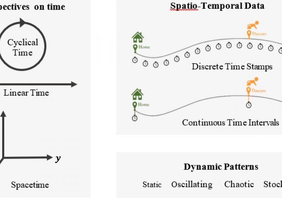
Time is a fundamental concept in geography and many other disciplines. This article introduces time at three levels. At the philosophical level, the article reviews various notions on the nature of time from early mythology to modern science and reveals the dual nature of reality: external (absolute, physical) and internal (perceived, cognitive). At the analytical level, it introduces the measurement of time, the two frames of temporal reference: calendar time and clock time, and the standard time for use globally. The article continues to discuss time in GIS at the practical level. The GISystem was first created as a “static” computer-based system that stores the present status of a dynamic system. Now, GISystems can track and model the dynamics in geographical phenomena and human-environment interactions. Representations of time in dynamic GISystems adopt three perspectives: discrete time, continuous time and Minkowski’s spacetime, and three representations: ordinal, interval, and cyclical. The appropriate perspective and representation depend on the observed temporal patterns, which can be static, oscillating, chaotic, or stochastic. Recent progress in digital technology brings us opportunities and challenges to collect, manage and analyze spatio-temporal data to advance our understanding of dynamical phenomena.

FC-07 - Space
  • Differentiate between absolute and relative descriptions of location
  • Define the four basic dimensions or shapes used to describe spatial objects (i.e., points, lines, regions, volumes)
  • Discuss the contributions that different perspectives on the nature of space bring to an understanding of geographic phenomenon
  • Justify the discrepancies between the nature of locations in the real world and representations thereof (e.g., towns as points)
  • Select appropriate spatial metaphors and models of phenomena to be represented in GIS
  • Develop methods for representing non-cartesian models of space in GIS
  • Discuss the advantages and disadvantages of the use of cartesian/metric space as a basis for GIS and related technologies
  • Differentiate between common-sense, Cartesian/metric, relational, relativistic, phenomenological, social constructivist, and other theories of the nature of space
FC-10 - Properties
  • Formalize attribute values and domains in terms of set theory
  • Develop alternative forms of representations for situations in which attributes do not adequately capture meaning
  • Define Stevens’ four levels of measurement (i.e., nominal, ordinal, interval, ratio)
  • Describe particular geographic phenomena in terms of attributes
  • Determine the proper uses of attributes based on their domains
  • Characterize the domains of attributes in a GIS, including continuous and discrete, qualitative and quantitative, absolute and relative
  • Recognize situations and phenomena in the landscape which cannot be adequately represented by formal attributes, such as aesthetics
  • Compare and contrast the theory that properties are fundamental (and objects are human simplifications of patterns thereof) with the theory that objects are fundamental (and properties are attributes thereof)
  • Recognize attribute domains that do not fit well into Stevens’ four levels of measurement such as cycles, indexes, and hierarchies
FC-09 - Relationships between space and time
  • Discuss common prepositions and adjectives (in any particular language) that signify either spatial or temporal relations but are used for both kinds, such as “after” or “longer”
  • Describe different types of movement and change
  • Understand the physical notions of velocity and acceleration which are fundamentally about movement across space through time
  • Identify various types of geographic interactions in space and time
  • Compare and contrast the characteristics of spatial and temporal dimensions
FC-08 - Time

Time is a fundamental concept in geography and many other disciplines. This article introduces time at three levels. At the philosophical level, the article reviews various notions on the nature of time from early mythology to modern science and reveals the dual nature of reality: external (absolute, physical) and internal (perceived, cognitive). At the analytical level, it introduces the measurement of time, the two frames of temporal reference: calendar time and clock time, and the standard time for use globally. The article continues to discuss time in GIS at the practical level. The GISystem was first created as a “static” computer-based system that stores the present status of a dynamic system. Now, GISystems can track and model the dynamics in geographical phenomena and human-environment interactions. Representations of time in dynamic GISystems adopt three perspectives: discrete time, continuous time and Minkowski’s spacetime, and three representations: ordinal, interval, and cyclical. The appropriate perspective and representation depend on the observed temporal patterns, which can be static, oscillating, chaotic, or stochastic. Recent progress in digital technology brings us opportunities and challenges to collect, manage and analyze spatio-temporal data to advance our understanding of dynamical phenomena.

FC-10 - Properties
  • Formalize attribute values and domains in terms of set theory
  • Develop alternative forms of representations for situations in which attributes do not adequately capture meaning
  • Define Stevens’ four levels of measurement (i.e., nominal, ordinal, interval, ratio)
  • Describe particular geographic phenomena in terms of attributes
  • Determine the proper uses of attributes based on their domains
  • Characterize the domains of attributes in a GIS, including continuous and discrete, qualitative and quantitative, absolute and relative
  • Recognize situations and phenomena in the landscape which cannot be adequately represented by formal attributes, such as aesthetics
  • Compare and contrast the theory that properties are fundamental (and objects are human simplifications of patterns thereof) with the theory that objects are fundamental (and properties are attributes thereof)
  • Recognize attribute domains that do not fit well into Stevens’ four levels of measurement such as cycles, indexes, and hierarchies
FC-09 - Relationships between space and time
  • Discuss common prepositions and adjectives (in any particular language) that signify either spatial or temporal relations but are used for both kinds, such as “after” or “longer”
  • Describe different types of movement and change
  • Understand the physical notions of velocity and acceleration which are fundamentally about movement across space through time
  • Identify various types of geographic interactions in space and time
  • Compare and contrast the characteristics of spatial and temporal dimensions
Pages