Foundational Concepts

The foundational concepts are the elementary building blocks and context setting constraints of all other entries in the BoK. The latter encompass the philosophical and mathematical support for GIScience as well as data models, while the constituent elements include, among others, notions of scale, spatial data quality, and openness. This knowledge area is also the place to look for the origins and future of GIScience.

Topics in this Knowledge Area are listed thematically below. Existing topics are in regular font and linked directly to their original entries (published in 2006; these contain only Learning Objectives). Entries that have been expanded and revised are in bold. Forthcoming, future topics are italicized

Origins Basic Measures
Intro to the GIS&T Body of Knowledge First & Second Laws of Geography
Public & Private Sector Origins Shape
Academic Developments of GIS&T Distance Operations
  Directional Operations
Cognitive Areal Interpolation
Perception & Cognitive Processing of Geographic Phenomena Proximity & Distance Decay
Foundational Ontologies Adjacency and Connectivity
Ontologies for Analysis & Formation of Geospatial Concepts Resolution
Place and Landscape Spatial Autocorrelation
The Power of Maps and Mapping Geometric Primitives and Algorithms
Semantic Information Elicitation Interrogating Geographic Information
Domains of Geographic Information Set Theory
Space Structured Query Language (SQL) and Attribute Queries
Time Spatial Queries
Relationships between Space and Time  
Data Properties Uncertainty
Networks Problems of Scale and Zoning
Events and Processes Thematic Accuracy and Assessment
Neighborhoods Conceptual Models of Error and Uncertainty
Philosophical  
Philosophical Perspectives  
Epistemology  
Openness  


FC-31 - Academic Developments of GIS&T in English-speaking Countries: a Partial History

The constellation of science and technology that is now considered a unit (Geographic Information Science and Technology – GIS&T) has emerged from many source disciplines through many divergent and convergent pasts in different times and places. This narrative limits itself to the perspective of the English-speaking community, leaving other regions for a separate chapter As in the case of many technical developments in the second half of the twentieth century, academic institutions played a key (though far from exclusive) role in innovation and risk-taking. In a number of locations, academic innovators tried out new technology for handling geographic information, beginning as early as the 1960s. Three institutions (University of Washington, Laboratory for Computer Graphics – Harvard University, and Experimental Cartography Unit – Royal College of Art (UK)) deserve particular treatment as examples of the early innovation process. Their innovations may look crude by current standards, but they laid some groundwork for later developments. Academic institutions played a key role in innovation over the past decades, but the positioning of that role has shifted as first government, then commercial sectors have taken the lead in certain aspects of GIS&T. Current pressures on the academic sector may act to reduce this role.

FC-18 - Adjacency and connectivity
  • List different ways connectivity can be determined in a raster and in a polygon dataset
  • Explain the nine-intersection model for spatial relationships
  • Demonstrate how adjacency and connectivity can be recorded in matrices
  • Calculate various measures of adjacency in a polygon dataset
  • Create a matrix describing the pattern of adjacency in a set of planar enforced polygons
  • Describe real world applications where adjacency and connectivity are a critical component of analysis
FC-16 - Area and Region
  • List reasons why the area of a polygon calculated in a GIS might not be the same as the real world object it describes
  • Demonstrate how the area of a region calculated from a raster data set will vary by resolution and orientation
  • Outline an algorithm to find the area of a polygon using the coordinates of its vertices
  • Explain how variations in the calculation of area may have real world implications, such as calculating density
  • Delineate regions using properties, spatial relationships, and geospatial technologies
  • Exemplify regions found at different scales
  • Explain the relationship between regions and categories
  • Identify the kinds of phenomena commonly found at the boundaries of regions
  • Explain why general-purpose regions rarely exist
  • Differentiate among different types of regions, including functional, cultural, physical, administrative, and others
  • Compare and contrast the opportunities and pitfalls of using regions to aggregate geographic information (e.g., census data)
  • Use established analysis methods that are based on the concept of region (e.g., landscape ecology)
  • Explain the nature of the Modifiable Areal Unit Problem (MAUP)
FC-24 - Conceptual Models of Error and Uncertainty

Uncertainty and error are integral parts of science and technology, including GIS&T, as they are of most human endeavors. They are important characteristics of knowledge, which is very seldom perfect. Error and uncertainty both affect our understanding of the present and the past, and our expectations from the future. ‘Uncertainty’ is sometimes used as the umbrella term for a number of related concepts, of which ‘error’ is the most important in GIS and in most other data-intensive fields. Very often, uncertainty is the result of error (or suspected error).  As concepts, both uncertainty and error are complex, each having several different versions, interpretations, and kinds of impacts on the quality of GIS products, and on the uses and decisions that users may make on their basis. This section provides an overview of the kinds of uncertainty and common sources of error in GIS&T, the role of a number of additional related concepts in refining our understanding of different forms of imperfect knowledge, the problems of uncertainty and error in the context of decision-making, especially regarding actions with important future consequences, and some standard as well as more exploratory approaches to handling uncertainties about the future. While uncertainty and error are in general undesirable, they may also point to unsuspected aspects of an issue and thus help generate new insights.

FC-14 - Directional Operations

In the same manner as distance, direction plays an equally important role in GIS. This article first summarizes different ways of measuring direction, either quantitatively or qualitatively. Formulas and examples are provided. In the following discussion, fundamental differences between distance and direction in describing spatial relations is examined; properties of angles are emphasized in the context of GIS; and the classification of both cardinal and projective direction is illustrated. With a focus on quantitative operations, various directional operations are categorized and elaborated based on factors such as the underlying data model (vector or raster) and whether direction effect is explicitly or implicitly embedded in the data.

FC-42 - Distance Operations

Distance is a central concept in geography, and consequently, there are various types of operations that leverage the concept of distance. This short article introduces common distance measures, the purpose of distance operations, different types of operations and considerations, as well as sample applications in the physical and social domains. Distance operations can be performed on both vector or raster data, but the operations and results may differ. While performing distance operations, it is important to remember how distance is conceptualized while performing the operation.

FC-02 - Epistemology

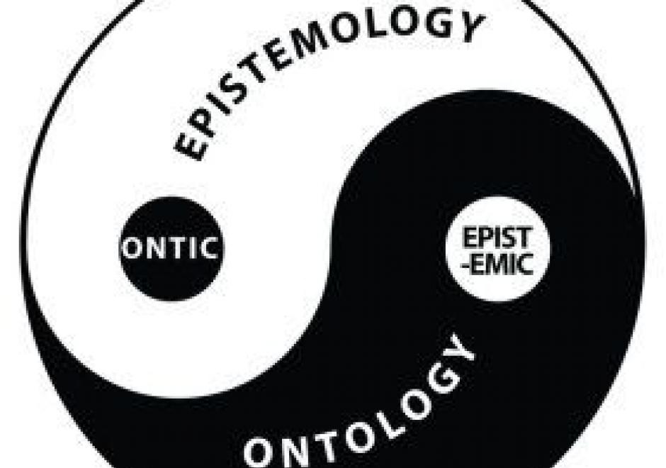
Epistemology is the lens through which we view reality. Different epistemologies interpret the earth and patterns on its surface differently. In effect, epistemology is a belief system about the nature of reality that, in turn, structures our interpretation of the world. Common epistemologies in GIScience include (but are not limited by) positivism and realism. However, many researchers are in effect pragmatists in that they choose the filter that best supports their work and a priori hypotheses. Different epistemologies – or ways of knowing and studying geography – result in different ontologies or classification systems. By understanding the role of epistemology, we can better understand different ways of representing the same phenomena.

FC-25 - Error
  • Compare and contrast how systematic errors and random errors affect measurement of distance
  • Describe the causes of at least five different types of errors (e.g., positional, attribute, temporal, logical inconsistency, and incompleteness)
FC-36 - Events and Processes
  • Compare and contrast the concepts of continuants (entities) and occurrents (events)
  • Describe the “actor” role that entities and fields play in events and processes
  • Discuss the difficulty of integrating process models into GIS software based on the entity and field views, and methods used to do so
  • Apply or develop formal systems for describing continuous spatio-temporal processes
  • Evaluate the assertion that “events and processes are the same thing, but viewed at different temporal scales”
  • Describe particular events or processes in terms of identity, categories, attributes, and locations
  • Compare and contrast the concepts of event and process
FC-05 - From concepts to data
  • Define the following terms: data, information, knowledge, and wisdom
  • Describe the limitations of various information stores for representing geographic information, including the mind, computers, graphics, and text
  • Transform a conceptual model of information for a particular task into a data model

Pages